IMAGES TAKEN NEAR TO
Lewes Road, FOREST ROW, RH18 5LG
Introduction
This page details the photographs taken nearby to Lewes Road, RH18 5LG by members of the Geograph project.
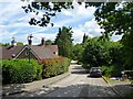
The Geograph project started in 2005 with the aim of publishing, organising and preserving representative images for every square kilometre of Great Britain, Ireland and the Isle of Man.

There are currently over 7.5m images from over14,400 individuals and you can help contribute to the project by visiting https://www.geograph.org.uk
Image Map
Images are licensed for reuse under creativecommons.org/licenses/by-sa/2.0
Notes
- Clicking on the map will re-center to the selected point.
- The higher the marker number, the further away the image location is from the centre of the postcode.
Image Listing (18 Images Found)
Images are licensed for reuse under creativecommons.org/licenses/by-sa/2.0
Image
Details
Distance
1
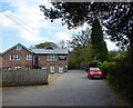
Highgate Works, Tomtits Lane, Forest Row
Originally a builders yard occupied by H & E Waters Ltd who went bust in 1991 - now a set of small business units.
Image: © Simon Carey
Taken: 15 Apr 2022
0.08 miles
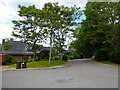
2
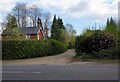
Poplar Lane, Forest Row
Unmade track linking Lewes Road, the A22, with Thompset's Bank. The building on the left is Cherry Tree Cottage.
Image: © Simon Carey
Taken: 15 Apr 2022
0.09 miles
3
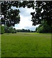
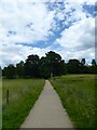
Kidbrooke Park
Viewed from Cowpath, the permissive footpath, that links Lewes Road, the A22, to the Michael Hall School and then Priory Road. Once part of Ashdown Forest, it was enclosed in the late 17th century and landscaped by Humphrey Repton in the 18th.
Image: © Simon Carey
Taken: 12 Jun 2022
0.12 miles
4
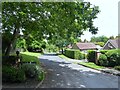
Chequer Grange, Forest Row
A cul de sac off Highgate Road named after the former farm located at the south east junction.
Image: © Simon Carey
Taken: 12 Jun 2022
0.14 miles
5
Highgate Road, Forest Row
Linking Lewes Road, the A22, and Chapel Lane. Beyond the black car on the right the road is unmade. The road itself may well run along or close to the former pale of Ashdown Forest. Chequer Farm is on the left.
Image: © Simon Carey
Taken: 12 Jun 2022
0.14 miles
6
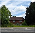
Hazel Cottage, Lewes Road, Forest Row
Dating from at least the 19th century.
Image: © Simon Carey
Taken: 12 Jun 2022
0.14 miles
7
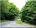
Lewes Road, Forest Row
Looking north from the junction with Highgate Road at the possible site of Highgate, one of the former medieval entrances to Ashdown Forest.
Image: © Simon Carey
Taken: 12 Jun 2022
0.15 miles
8
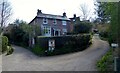
Laura House, Inkpen Lane, Forest Row
Built in 1890 by a local builder, Job Luxford, for his sister Laura. Located at the junction of Highgate Road and Inkpen Lane.
Image: © Simon Carey
Taken: 15 Apr 2022
0.17 miles
9
Michael Fields, Forest Row
A cul de sac off Gage Ridge and part of development built on the northern part of Kidbrooke Park, whose previous owners are recorded in the road names.
Image: © Simon Carey
Taken: 12 Jun 2022
0.17 miles
10
Cowpath, Kidbrooke Park
Linking the Michael Hall School with lewes Road, the A22. The path is permissive and allows access between the A22 and Priory Road.
Image: © Simon Carey
Taken: 12 Jun 2022
0.18 miles