IMAGES TAKEN NEAR TO
Lewes Road, HAYWARDS HEATH, RH17 7TA
Introduction
This page details the photographs taken nearby to Lewes Road, RH17 7TA by members of the Geograph project.
The Geograph project started in 2005 with the aim of publishing, organising and preserving representative images for every square kilometre of Great Britain, Ireland and the Isle of Man.

There are currently over 7.5m images from over14,400 individuals and you can help contribute to the project by visiting https://www.geograph.org.uk
Image Map
Images are licensed for reuse under creativecommons.org/licenses/by-sa/2.0
Notes
- Clicking on the map will re-center to the selected point.
- The higher the marker number, the further away the image location is from the centre of the postcode.
Image Listing (22 Images Found)
Images are licensed for reuse under creativecommons.org/licenses/by-sa/2.0
Image
Details
Distance
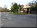
1
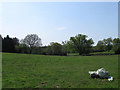
Three Acres
The name of the field according to Wivelsfield's 1843 tithe map viewed from Lewes Road. The land here is now part of Haywards Heath.
Image: © Simon Carey
Taken: 20 Apr 2011
0.05 miles
6
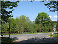
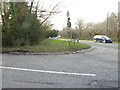
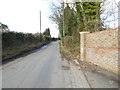
Lewes Road
The A272 as viewed from the junction of Slugwash Lane. Once the very north east tip of the parish of Wivelsfield which was transferred to Haywards Heath in 1934.
Image: © Simon Carey
Taken: 20 Apr 2011
0.13 miles
7
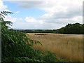
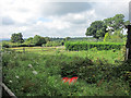
Field Number 1092
The number of the field according to Lindfield's 1845 tithe map that was not named on the survey. Located to the south of Snowdrop Lane with views of the Weald in the distance.
Image: © Simon Carey
Taken: 4 Aug 2015
0.14 miles
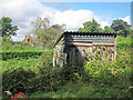
8
Lodge at northern end of Slugwash Lane
This now houses an osteopathic clinic.
Image: © Shazz
Taken: 7 Mar 2017
0.15 miles
10
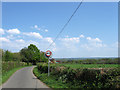
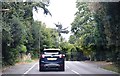
Snowdrop Lane
Up until the 1960s the road was called Sluts Lane but was changed for some reason to that of the pub which can be seen in the distance. The Wealden countryside between Scaynes Hill and Chailey can be seen in the distance on the next ridge.
Image: © Simon Carey
Taken: 20 Apr 2011
0.15 miles