IMAGES TAKEN NEAR TO
Colwell Lane, HAYWARDS HEATH, RH17 7QZ
Introduction
This page details the photographs taken nearby to Colwell Lane, RH17 7QZ by members of the Geograph project.
The Geograph project started in 2005 with the aim of publishing, organising and preserving representative images for every square kilometre of Great Britain, Ireland and the Isle of Man.

There are currently over 7.5m images from over14,400 individuals and you can help contribute to the project by visiting https://www.geograph.org.uk
Image Map
Images are licensed for reuse under creativecommons.org/licenses/by-sa/2.0
Notes
- Clicking on the map will re-center to the selected point.
- The higher the marker number, the further away the image location is from the centre of the postcode.
Image Listing (47 Images Found)
Images are licensed for reuse under creativecommons.org/licenses/by-sa/2.0
Image
Details
Distance
1
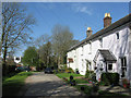
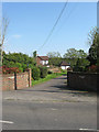
Hurstwood Cottages
Located at the point where Colwell Lane ceases to be a metalled road. The cottages were built in the mid 19th century possibly along with nearby Hurstwood House just visible to the left which was constructed in 1869 on the site of a former tanyard.
Image: © Simon Carey
Taken: 10 Apr 2011
0.02 miles
2
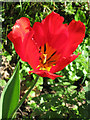
Tulip, Colwell Lane
Growing by itself on a verge on the northern side of Colwell Lane.
Image: © Simon Carey
Taken: 10 Apr 2011
0.02 miles
4
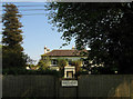
Hurstwood Place
Viewed from Hurstwood Lane and built in 1870 on the site of Wivelsfield's former medieval tanyard that operated from the 14th century to the 1830s when it was unsuccessfully put up for sale. Although marked as a tannery on the 1843 tithe map it was no longer operational. Nothing much remains though the grounds of the house has a few ponds that were converted from the 65 pits a tanyard was once required to possess. The building was originally called Hurstwood House.
Image: © Simon Carey
Taken: 20 Apr 2011
0.04 miles
5
Hurstwood Lodge
Viewed from Hurstwood Lane and the neighbour of Image for which it seems it was an outbuilding off until the 1970s when it became dwelling in its own right.
Image: © Simon Carey
Taken: 20 Apr 2011
0.04 miles
6
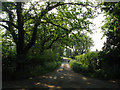
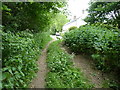
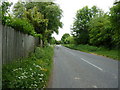
Colwell Lane
An old lane that links Hurstwood Lane to Lewes Road, the A273. The lane is only metalled as far as Image when it becomes a restricted byway through Hurst Wood. It resumes being suitable for vehicles at the Image albeit very narrow.
Image: © Simon Carey
Taken: 30 Apr 2011
0.05 miles
7
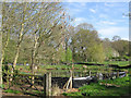
Stable Field
The name of the field according to the 1843 tithe map, the pond seems to be a recent edition.
Image: © Simon Carey
Taken: 10 Apr 2011
0.05 miles
8
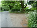
Colwell Lane off Hurstwood Lane
After a quarter of a mile it becomes a restricted byway.
Image: © Dave Spicer
Taken: 15 May 2011
0.06 miles
10
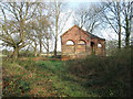
Old Pump House
Just off Hurstwood Lane near the junction with Colwell Lane. Not sure if it is still in use, however, it lies near the source of Pellingford Brook a tributary of the River Ouse.
Image: © Simon Carey
Taken: 10 Apr 2011
0.09 miles