IMAGES TAKEN NEAR TO
Green Road, HAYWARDS HEATH, RH17 7QB
Introduction
This page details the photographs taken nearby to Green Road, RH17 7QB by members of the Geograph project.
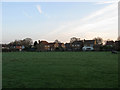
The Geograph project started in 2005 with the aim of publishing, organising and preserving representative images for every square kilometre of Great Britain, Ireland and the Isle of Man.

There are currently over 7.5m images from over14,400 individuals and you can help contribute to the project by visiting https://www.geograph.org.uk
Image Map
Images are licensed for reuse under creativecommons.org/licenses/by-sa/2.0
Notes
- Clicking on the map will re-center to the selected point.
- The higher the marker number, the further away the image location is from the centre of the postcode.
Image Listing (62 Images Found)
Images are licensed for reuse under creativecommons.org/licenses/by-sa/2.0
Image
Details
Distance
1
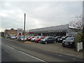
Barnard & Brough car dealership, Wivelsfield
Image: © Stacey Harris
Taken: 11 Mar 2012
0.01 miles
2
Barnard & Brough, Green Road
Used car dealer on the corner of Green Road and Blackmores. There seems to have been a garage at this location since at least the 1960s.
Image: © Simon Carey
Taken: 20 Apr 2011
0.02 miles
3
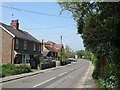
Houses, Green Road
To the left are Stream Villas built as a pair of houses in the 1900s, beyond that is Stream House that was rebuilt on the site of an older house as a single dwelling in the early 1800s and originally known as Stream Cottage. It was divided in 1959 with the western part becoming Avery House after the name of a butcher which once operated from that portion of the building. On the right obscured by the foliage is the old village K6 telephone box.
Image: © Simon Carey
Taken: 24 Apr 2011
0.03 miles
4
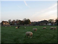
Osborn Field
The name of the field according to Wivelsfield's 1843 tithe map that has been extended to include Image to the south. The houses and barn belong to Blackmores a modern cul-de-sac built on the site of Blackmores Farm which disappeared in the 1960s and was initially replaced with an abattoir before the construction of the estate in the last decade.
Image: © Simon Carey
Taken: 10 Apr 2011
0.05 miles
5
Hut Field
The name of the field according to Wivelsfield's 1843 tithe map that has been extended to include Image to the south. The houses at the end of the field are in a modern cul-de-sac called Blackmores built on the site of Blackmores Farm which disappeared in the 1960s to be initially replaced by an abattoir prior to the estate being built about a decade a go.
Image: © Simon Carey
Taken: 10 Apr 2011
0.05 miles
6
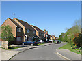
Blackmores
A cul-de-sac off Green Road named after the former medieval farm that it was built on. The farm disappeared in the 1960s and was initially replaced by an abattoir which was demolished when the new estate was constructed in the last decade.
Image: © Simon Carey
Taken: 20 Apr 2011
0.06 miles
7
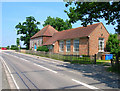
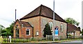
Ote Hall Congregational Chapel, Ditchling Road
Baptist chapel built by the Countess of Huntingdon who lived in nearby Great Ote Hall in 1778.
Image: © Simon Carey
Taken: 8 Jun 2008
0.07 miles
8
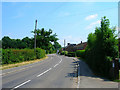
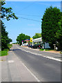
Green Road
Minor road linking Wivelsfield with North Chailey. The settlement of Wivelsfield Green is spread out along it.
Image: © Simon Carey
Taken: 8 Jun 2008
0.08 miles
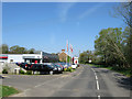
10
Baldocks Garage, Ditchling Road
The firm has been located at this spot on the B2112 for nearly 40 years.
Image: © Simon Carey
Taken: 8 Jun 2008
0.08 miles