IMAGES TAKEN NEAR TO
Sloop Lane, HAYWARDS HEATH, RH17 7NP
Introduction
This page details the photographs taken nearby to Sloop Lane, RH17 7NP by members of the Geograph project.
The Geograph project started in 2005 with the aim of publishing, organising and preserving representative images for every square kilometre of Great Britain, Ireland and the Isle of Man.

There are currently over 7.5m images from over14,400 individuals and you can help contribute to the project by visiting https://www.geograph.org.uk
Image Map
Images are licensed for reuse under creativecommons.org/licenses/by-sa/2.0
Notes
- Clicking on the map will re-center to the selected point.
- The higher the marker number, the further away the image location is from the centre of the postcode.
Image Listing (58 Images Found)
Images are licensed for reuse under creativecommons.org/licenses/by-sa/2.0
Image
Details
Distance
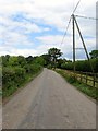
1
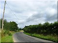
Sloop Lane
A view of the lane as it curves westwards from Image to Image with Image beyond the hedge to the right. The lane links Freshfield Bridges to Freshfield Crossways.
Image: © Simon Carey
Taken: 4 Aug 2015
0.06 miles
2
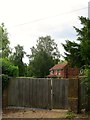
The Millers, Sloop Lane
Originally two cottages dating from the early 18th century which were later joined together to become The Millers Arms an alehouse. Marked as such on the 1876 OS map but not on the following 1899 edition. Now a single dwelling.
Image: © Simon Carey
Taken: 31 Jul 2015
0.06 miles
3
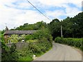
Freshmill Cottage, Sloop Lane
Located to the immediate south of Image it is marked on Horsted Keynes's 1842 tithe map and looks like at one point in time it was two cottages.
Image: © Simon Carey
Taken: 31 Jul 2015
0.08 miles
4
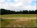
Kiln Field
The name of the field according to Horsted Keynes's 1842 tithe map viewed from Sloop Lane.
Image: © Simon Carey
Taken: 4 Aug 2015
0.08 miles
5
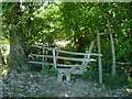
Somewhat hidden stile and signpost near Sloop Lane
Image: © Shazz
Taken: 21 May 2011
0.08 miles
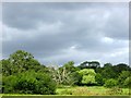
6
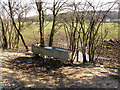
Water for the sheep
The trough is in the corner of a large field Image
Image: © Stephen Craven
Taken: 1 Apr 2013
0.09 miles
7
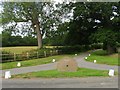
Entrance to Town House Farm
Utilising an old millstone possibly from Freshfield Mill down the road as a sign. The entrance here is flanked by Image to the south and Image to the north.
Image: © Simon Carey
Taken: 4 Aug 2015
0.10 miles
8
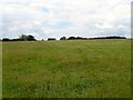
Well Field/Kiln Field
The name of the fields according to Horsted Keynes's 1842 tithe map that have been merged along with Image to the east of the public footpath to form a larger unit. Well Field was to the south whilst Kiln Field was further up the slope adjacent to the Bluebell Railway. To the west is Sloop Lane.
Image: © Simon Carey
Taken: 31 Jul 2015
0.11 miles
9
Sloop Lane
Heading north from Freshfield bridges to Freshfield crossways where the lane becomes Freshfield Lane as it continues on to Danehill. Amongst the foliage to the left is a raised walk for times when the area is flooded though it is very overgrown at present.
Image: © Simon Carey
Taken: 31 Jul 2015
0.12 miles
10
Fine Meadow
The name of the field according to Lindfield's 1845 tithe map that is located within a meander of the River Ouse and bounded to the south by the former Ouse Navigation. The field in the foreground is Image
Image: © Simon Carey
Taken: 4 Aug 2015
0.12 miles