IMAGES TAKEN NEAR TO
Charters Gate Way, HAYWARDS HEATH, RH17 7EW
Introduction
This page details the photographs taken nearby to Charters Gate Way, RH17 7EW by members of the Geograph project.
The Geograph project started in 2005 with the aim of publishing, organising and preserving representative images for every square kilometre of Great Britain, Ireland and the Isle of Man.

There are currently over 7.5m images from over14,400 individuals and you can help contribute to the project by visiting https://www.geograph.org.uk
Image Map
Images are licensed for reuse under creativecommons.org/licenses/by-sa/2.0
Notes
- Clicking on the map will re-center to the selected point.
- The higher the marker number, the further away the image location is from the centre of the postcode.
Image Listing (66 Images Found)
Images are licensed for reuse under creativecommons.org/licenses/by-sa/2.0
Image
Details
Distance
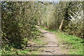
4
Bridleway running south from Wivelsfield Green
Image: © Dave Spicer
Taken: 4 Jul 2009
0.08 miles
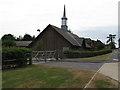
5
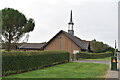
Church of Jesus Christ of the Latter Day Saints
Image: © N Chadwick
Taken: 13 Sep 2021
0.08 miles
6
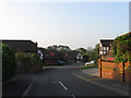
Farncombe Close
A small cul-de-sac off North Common Road. In Wivelsfield's 1843 tithe survey it was part of Image and remained so until the 1920s when it was developed as an extension to Albion Nurseries. Its successor eventually closed in the 1990s and the plot of land was developed as a small estate in the mid 1990s.
Image: © Simon Carey
Taken: 24 Apr 2011
0.08 miles
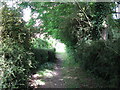
8
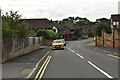
Albion Nursery, North Common Road
The name of the house on the left that was built in the 1920s as part of a nursery expansion. The nurseries remained until the 1980s when the land was sold and Image constructed leaving just this house as a reminder.
Image: © Simon Carey
Taken: 24 Apr 2011
0.09 miles
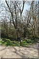
10
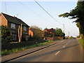
Gate Field
The name of the field according to Wivelsfield's 1843 tithe map. Once a much larger field that has now been split into four separate pieces; one containing Image, another the recently constructed Image, this piece of rough ground to the east, and a much smaller field to the south.
Image: © Simon Carey
Taken: 24 Apr 2011
0.09 miles