IMAGES TAKEN NEAR TO
Warninglid Lane, HAYWARDS HEATH, RH17 5TY
Introduction
This page details the photographs taken nearby to Warninglid Lane, RH17 5TY by members of the Geograph project.
The Geograph project started in 2005 with the aim of publishing, organising and preserving representative images for every square kilometre of Great Britain, Ireland and the Isle of Man.

There are currently over 7.5m images from over14,400 individuals and you can help contribute to the project by visiting https://www.geograph.org.uk
Image Map
Images are licensed for reuse under creativecommons.org/licenses/by-sa/2.0
Notes
- Clicking on the map will re-center to the selected point.
- The higher the marker number, the further away the image location is from the centre of the postcode.
Image Listing (38 Images Found)
Images are licensed for reuse under creativecommons.org/licenses/by-sa/2.0
Image
Details
Distance
1
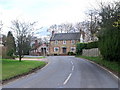
Warninglid Lane, Warninglid, West Sussex
Image: © nick macneill
Taken: 11 Mar 2011
0.01 miles
2
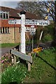
Direction Sign - Signpost in Warninglid
Black iron cap finial - 3 arms; East Sussex wood by the UC road, in parish of Slaugham (Mid Sussex District), B2115, Warninglid Lane, Cuckfield Lane, on verge at village crossroads where Slaugham Lane and The Street cross the B2115.
Surveyed
Milestone Society National ID: SX_TQ2526
Image: © Milestone Society
Taken: Unknown
0.02 miles
3
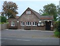
Seaforth Hall, Warninglid, West Sussex
The village hall at Warninglid. Built in the early 20th century using money donated by Lady Seaforth. A plaque near the apex of the roof gives details of the dedication (see supplemental picture). Located a short distance E of the crossroads, on the N side of Cuckfield Lane.
Image: © Pete Chapman
Taken: 8 Oct 2005
0.03 miles
4
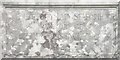
Dedication Plaque at Seaforth Hall, Warninglid, West Sussex
Located near the apex of the roof.
"Erected by Lady Seaforth in Memory of Her Father Mr Edward Steinkopff of (???), 1925"
Image: © Pete Chapman
Taken: 8 Oct 2005
0.03 miles
5
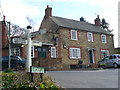
The Half Moon
Well-to-do High Weald village inn, stone-built, on the crossroads at Warninglid.
Image: © Colin Smith
Taken: 1 Mar 2008
0.03 miles
6
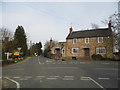
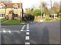
Crossroads on Warninglid Lane
Looking towards Cuckfield Lane and the Half Moon Pub
Image: © David Howard
Taken: 7 Apr 2013
0.03 miles
7
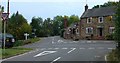
Crossroads at Warninglid, West Sussex.
The small village of Warninglid spreads for a few hundred metres S and E of this crossroads on the B2115. The "Half Moon" pub (shown on the left of the photo) is located here. View taken from the Horsham direction looking E. A finger post (see http://www.geograph.org.uk/photo/63503) gives directions to travellers.
Image: © Pete Chapman
Taken: 8 Oct 2005
0.03 miles
8
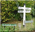
Finger Post at Crossroads, Warninglid, West Sussex.
N Direction (Slaugham Lane): Slaugham; and Handcross.
S Direction: Bolney.
E Direction (Cuckfield Lane): Balcombe; and Haywards Heath (via Cuckfield).
W Direction: Cowfold; and Horsham.
Image: © Pete Chapman
Taken: 8 Oct 2005
0.03 miles
9
Looking north at Warninglid cross roads
Temporarily a Tee junction see Image
Image: © Dave Spicer
Taken: 24 Jan 2009
0.04 miles
10
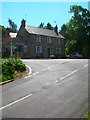
The Half Moon
Standing at the crossroads in the small village of Warninglid, the building is grade II listed and dates back to the 18th century. The road running from bottom left to right is the minor lane from Slaugham that continues down the village street. The one coming from the mid left is Cuckfield Lane, the B2115, which continues onto Plummers Plain and Lower Beeding.
Image: © Simon Carey
Taken: 24 Jul 2008
0.04 miles