IMAGES TAKEN NEAR TO
Crossways, HAYWARDS HEATH, RH17 5RN
Introduction
This page details the photographs taken nearby to Crossways, RH17 5RN by members of the Geograph project.
The Geograph project started in 2005 with the aim of publishing, organising and preserving representative images for every square kilometre of Great Britain, Ireland and the Isle of Man.

There are currently over 7.5m images from over14,400 individuals and you can help contribute to the project by visiting https://www.geograph.org.uk
Image Map
Images are licensed for reuse under creativecommons.org/licenses/by-sa/2.0
Notes
- Clicking on the map will re-center to the selected point.
- The higher the marker number, the further away the image location is from the centre of the postcode.
Image Listing (28 Images Found)
Images are licensed for reuse under creativecommons.org/licenses/by-sa/2.0
Image
Details
Distance
1
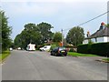
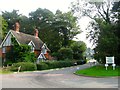
Cottages, Crossways, Bolney
Forde Cottage is the white building on the right whilst the roof of West Cottage and Brook Cottage is to the left. Crossways was the original course of the 1813 London-Brighton turnpike that remained the main A23 until the Bolney Flyover was constructed in 1972 then being relegated to a slip road for southbound traffic wishing to join the A272. Further realignment in the early 1990s included a new southbound slip road and relegated the road to a cul de sac whose end can be seen in the distance.
Image: © Simon Carey
Taken: 7 Sep 2014
0.02 miles
2
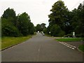
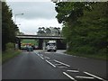
Crossways, Bolney
Currently a cul de sac off Image providing access to Brook Cottage and West Cottages, however, it was the original course of London Road until 1972 when the Bolney Flyover was built whereupon it became a slip road for southbound traffic wishing to join the A272. This lasted until the early 1990s when the junction was reconfigured and a new southbound slip road was constructed which consequently blocked off access to the road.
Image: © Simon Carey
Taken: 31 Aug 2014
0.02 miles
3
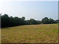
Lane Field
The name of the field according to Bolney's 1842 tithe map that is located to the south of Image separated only by Image To the west is Image whilst to the east is Image
Image: © Simon Carey
Taken: 7 Sep 2014
0.05 miles
4
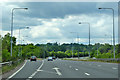
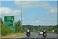
A23 northbound
At the slip road to the A273.
Image: © Robin Webster
Taken: 25 May 2019
0.06 miles
5
Redwoods, Crossways, Bolney
Built as a substantial Edwardian lodge for Gravenhurst, a large 19th century house first renamed Bolney Court, which was later converted into a school, Farney Close, in the early 1960s. The former lodge was given its current name sometime after, appearing as it on the 1974 OS map.
Image: © Simon Carey
Taken: 7 Sep 2014
0.08 miles
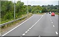
8
Looking east to the A23 flyover across the A272
Image: © David Smith
Taken: 1 May 2014
0.12 miles
9
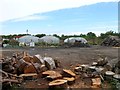
Marylands Nursery, Cowfold Road, Bolney
Established a couple of years ago and occupying an area bounded by the A23, its slip road and the A272, once a couple of fields called Broom Field and Clapper Field. Compared to neighbouring Image facilities seem to be a bit more rudimentary.
Image: © Simon Carey
Taken: 31 Aug 2014
0.12 miles
10
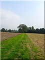
Footpath to Buncton Lane
Heading east from the end of Crossways and here separating Image on the left from Image to the right, with the lone oak the sole survivor of the former hedgerow that once separated them. Beyond the hedgerow in the distance is Image
Image: © Simon Carey
Taken: 7 Sep 2014
0.12 miles