IMAGES TAKEN NEAR TO
Crossways, HAYWARDS HEATH, RH17 5RD
Introduction
This page details the photographs taken nearby to Crossways, RH17 5RD by members of the Geograph project.
The Geograph project started in 2005 with the aim of publishing, organising and preserving representative images for every square kilometre of Great Britain, Ireland and the Isle of Man.

There are currently over 7.5m images from over14,400 individuals and you can help contribute to the project by visiting https://www.geograph.org.uk
Image Map
Images are licensed for reuse under creativecommons.org/licenses/by-sa/2.0
Notes
- Clicking on the map will re-center to the selected point.
- The higher the marker number, the further away the image location is from the centre of the postcode.
Image Listing (31 Images Found)
Images are licensed for reuse under creativecommons.org/licenses/by-sa/2.0
Image
Details
Distance
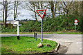
1
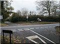
Road junction
Where Stairbridge Lane and Buncton Lane meet the A272 near to Bolney, West Sussex.
Image: © Chris Plunkett
Taken: 27 Nov 2005
0.07 miles
2
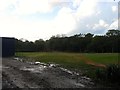
Brook Field
The name of the field according to Bolney's 1842 tithe map that is now part of the grounds of Farney Close School.
Image: © Simon Carey
Taken: 11 Oct 2014
0.09 miles
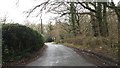
4
Stairbridge lane reaches the A272
The A272 is known as Bolney Road here. Stairbridge Lane joins Buncton Lane at the main road. For a view the other way see http://www.geograph.org.uk/photo/4209349.
Image: © Shazz
Taken: 18 Nov 2016
0.11 miles
5
Crossroads on A272
While the A272 is signed as going somewhere, if not coming from anywhere, Buncton Lane and Stairbridge Lane are only acknowledged to exist, without going anywhere in particular.
Image: © Robin Webster
Taken: 5 Apr 2010
0.11 miles
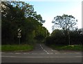
6
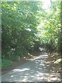
Approaching the A272
On Stairbridge Lane looking towards the junction with the A272 and Buncton Lane.
Image: © Chris Thomas-Atkin
Taken: 31 Dec 2017
0.11 miles
7
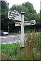
Direction Sign - Signpost by the A272
Black iron cap finial - 3 arms; East Sussex wood with number by the A272, in parish of Bolney (Mid Sussex District), Bolney Road, on verge at crossroads where Stairbridge Lane and Buncton Lane meet the A272, Bolney Road.
Surveyed
Milestone Society National ID: SX_TQ2722
Image: © Milestone Society
Taken: Unknown
0.12 miles
8
Stairbridge Lane
Originally a continuation of Buncton Lane and thus an old droving route. The crossroads arrived in 1825 with the building of a new turnpike that would become the A272.
Image: © Simon Carey
Taken: 11 Oct 2014
0.12 miles
9
Five Acres/Kiln Field
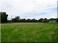
The name of the fields according to Bolney's 1842 tithe map that have been merged to form a larger unit. Five Acres was in the foreground to the south, Kiln Field in the distance to the north, part of which has been lost to the construction of Honeysuckle Cottage between the wars. The field is bounded by Image and Image to the west, the A272 to the north, Stairbridge Lane to the east and Image to the south. The field also contains Image
Image: © Simon Carey
Taken: 31 Aug 2014
0.13 miles
10
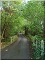
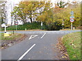
Buncton Lane
Heading south over an unnamed tributary of the River Adur towards its southern junction with the A272. The lane from this point southwards is the parish boundary between Cuckfield to the left and Bolney to the right. Also on the left is North Wood.
Image: © Simon Carey
Taken: 11 Oct 2014
0.14 miles