IMAGES TAKEN NEAR TO
Partridge Land, HAYWARDS HEATH, RH17 5QS
Introduction
This page details the photographs taken nearby to Partridge Land, RH17 5QS by members of the Geograph project.
The Geograph project started in 2005 with the aim of publishing, organising and preserving representative images for every square kilometre of Great Britain, Ireland and the Isle of Man.

There are currently over 7.5m images from over14,400 individuals and you can help contribute to the project by visiting https://www.geograph.org.uk
Image Map
Images are licensed for reuse under creativecommons.org/licenses/by-sa/2.0
Notes
- Clicking on the map will re-center to the selected point.
- The higher the marker number, the further away the image location is from the centre of the postcode.
Image Listing (15 Images Found)
Images are licensed for reuse under creativecommons.org/licenses/by-sa/2.0
Image
Details
Distance
1
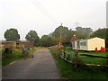
Michaelmas Barn, Bolney Chapel Road, Twineham Green
A converted barn once belonging to Partridge Farm whose chimney can be seen beyond to the right
Image: © Simon Carey
Taken: 7 Sep 2014
0.01 miles
2
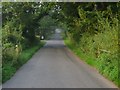
Bolney Chapel Road
Crossing the bridge of an unnamed tributary of the eastern branch of the River Adur and entering the parish of Twineham. The road is part of an old drove road that can be traced starting at Poynings at the foot of the Downs then heading northwards through High Cross, Twineham, Twineham Green and Crosspost before reaching the wooded pastures north east of Bolney.
Image: © Simon Carey
Taken: 7 Sep 2014
0.03 miles
3
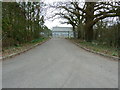
Entrance to Hillmans Farm Business Estate
Image: © Dave Spicer
Taken: 6 Mar 2011
0.13 miles
4
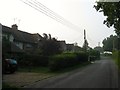
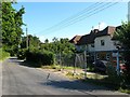
Council Cottages, Bolney Chapel Road, Twineham Green
A set of three semi-detached cottages built between the wars. See also Image for a view of the southern one.
Image: © Simon Carey
Taken: 7 Sep 2014
0.18 miles
5
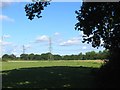
Six Acre Bob Field/Granary Field
The name of the fields according to Twineham's 1837 tithe map that have been merged to form a larger unit along with Image to the west. Six Acre Bob Field was to the south adjacent to Bob Lane whilst granary Field was to the north
Image: © Simon Carey
Taken: 23 Aug 2014
0.18 miles
6
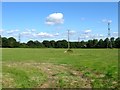
Five Acres/Nine Acres
The name of the fields according to Twineham's 1837 tithe map that have been merged together along with Image to the east to form a larger unit. Five Acres was to the south adjacent to Image whilst Nine Acres occupied the northern part. The pylons are heading to Image which lies a mile or so to the west.
Image: © Simon Carey
Taken: 23 Aug 2014
0.18 miles
7
Houses at Twineham Green
Looking across the corner at the end of Bob Lane.
Image: © Robin Webster
Taken: 5 Apr 2010
0.18 miles
8
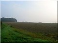
Seven Acres
The name of the field according to Bolney's 1842 tithe map that lies to the east of Bolney Chapel Road. The clump of trees on top of the slope contain Image
Image: © Simon Carey
Taken: 7 Sep 2014
0.19 miles
9
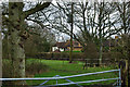
Council Cottages, Bolney Chapel Road, Twineham Green
This is the southern most of a set of three semi-detached cottages built between the wars on Bolney Chapel Road near the junction with Bob Lane.
Image: © Simon Carey
Taken: 23 Aug 2014
0.20 miles
10
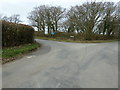
Bob Lane at Twineham Green
Bob Lane runs west from here to Wineham Lane.
Image: © Dave Spicer
Taken: 6 Mar 2011
0.21 miles