IMAGES TAKEN NEAR TO
Top Street, HAYWARDS HEATH, RH17 5PP
Introduction
This page details the photographs taken nearby to Top Street, RH17 5PP by members of the Geograph project.
The Geograph project started in 2005 with the aim of publishing, organising and preserving representative images for every square kilometre of Great Britain, Ireland and the Isle of Man.

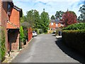
There are currently over 7.5m images from over14,400 individuals and you can help contribute to the project by visiting https://www.geograph.org.uk
Image Map
Images are licensed for reuse under creativecommons.org/licenses/by-sa/2.0
Notes
- Clicking on the map will re-center to the selected point.
- The higher the marker number, the further away the image location is from the centre of the postcode.
Image Listing (88 Images Found)
Images are licensed for reuse under creativecommons.org/licenses/by-sa/2.0
Image
Details
Distance
1
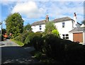
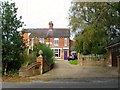
White House, Top Street, Bolney
Built in the 19th century and opened as a Mission Room in 1885 before Image was built in 1901 on the opposite side of the road.
Image: © Simon Carey
Taken: 25 Sep 2014
0.01 miles
2
Bolney Village chapel, Top Street, Bolney
Opened in 1901 opposite Image which had previously been the village Mission Room.
Image: © Simon Carey
Taken: 25 Sep 2014
0.01 miles
3

The Common, Bolney
A small cul de sac heading north of Top Street and built sometime in the 1960s on the site of a former nursery. The northern end of the village is often known locally as The Common having grown up from the enclosure of the old common in 1841.
Image: © Simon Carey
Taken: 19 Sep 2014
0.02 miles
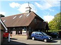
4

Village Chapel, Top Street, Bolney
This smart new building also serves as a community centre for the "top" end of the village.
Image: © Kevin Gordon
Taken: 18 Oct 2008
0.02 miles
5
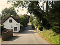
Top Street, Bolney
Top Street was laid out as a road after the enclosure of Bolney Common in 1841, it runs west from London Road to The Street. To the left is Windmill Cottage, a reminder of the former Bolney Mill which once stood on the old common from the 1770s until it was demolished in 1916 having ceased commercial production around the early 1890s. The junction with Cherry Lane can be seen in the dip.
Image: © Simon Carey
Taken: 19 Sep 2014
0.02 miles
6
Top Street, Bolney
The houses on the right were built in 1988 on the site of the former village general store which operated from the last quarter of the 19th century until its closure in 1965. Beyond the red car is the junction with Image built on the rest of the grounds of the former shop and Image
Image: © Simon Carey
Taken: 25 Sep 2014
0.03 miles
7

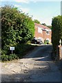
Cherry Lane, Bolney
Top Street is the road in the foreground.
Image: © Kevin Gordon
Taken: 18 Oct 2008
0.04 miles
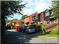
8
Springfield Close, Bolney
Built in 1988 on the site of the former village stores, see also Image The cul de sac is located off Top Street.
Image: © Simon Carey
Taken: 25 Sep 2014
0.05 miles
9
Oxford House, Cherry Lane, Bolney
Built in the late 19th century and one of a pair of semi-detached houses, its neighbour to the left being Cambridge House.
Image: © Simon Carey
Taken: 31 Aug 2014
0.05 miles
10
Scarps Meadow Cottages, The Street, Bolney
The northern most dwellings on the eastern side of The Street were built sometime in the 1970s.
Image: © Simon Carey
Taken: 25 Sep 2014
0.06 miles