IMAGES TAKEN NEAR TO
Glebe Road, HAYWARDS HEATH, RH17 5GU
Introduction
This page details the photographs taken nearby to Glebe Road, RH17 5GU by members of the Geograph project.
The Geograph project started in 2005 with the aim of publishing, organising and preserving representative images for every square kilometre of Great Britain, Ireland and the Isle of Man.

There are currently over 7.5m images from over14,400 individuals and you can help contribute to the project by visiting https://www.geograph.org.uk
Image Map
Images are licensed for reuse under creativecommons.org/licenses/by-sa/2.0
Notes
- Clicking on the map will re-center to the selected point.
- The higher the marker number, the further away the image location is from the centre of the postcode.
Image Listing (67 Images Found)
Images are licensed for reuse under creativecommons.org/licenses/by-sa/2.0
Image
Details
Distance
1
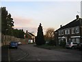
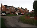
Mytten Close, Cuckfield
This is a western extension of the cul de sac added in the mid 1970s in the former grounds of Mytten House which still exists behind the fence to the left.
Image: © Simon Carey
Taken: 20 Dec 2014
0.07 miles
2
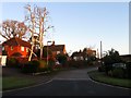
Mytten Close, Cuckfield
This section of Mytten Close was built in the 1960s in the grounds of a large house called Myttens which still stands but is now surrounded by the estate. According to Cuckfield's 1843 tithe map this was once a field called Bull Field.
Image: © Simon Carey
Taken: 17 Feb 2015
0.09 miles
3
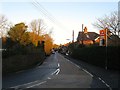
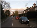
London Lane, Cuckfield
The B2184 that connects Broad Street with the B2036 next to the Rose & Crown public house. Much of the housing on the right was built in the first decade of the 20th century. A busy road that enables drivers to avoid the centre of Cuckfield.
Image: © Simon Carey
Taken: 17 Feb 2015
0.09 miles
4
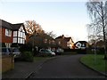
Hatchlands, Cuckfield
A small cul de sac off Broad Street that was developed in the 1980s in the grounds of a former Victorian townhouse of the same name. Unlike neighbouring Myttens the house was demolished.
Image: © Simon Carey
Taken: 17 Feb 2015
0.09 miles
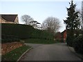
5
Little Ledgers, Cuckfield
A small cul de sac containing four dwellings off London Lane built in 1997.
Image: © Simon Carey
Taken: 20 Dec 2014
0.10 miles
6
The Hardings, London Lane, Cuckfield
A pair of semi-detached Edwardian cottages near the western end of London Lane.
Image: © Simon Carey
Taken: 20 Dec 2014
0.11 miles
7
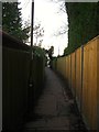
Mytten Twitten, Cuckfield
A narrow alley that runs from the High Street to London Lane. Marked as Mytten Lane on all OS maps up to 1938 acquiring its current name by the 1956 edition. This section looks down towards Mytten Close after which it swings west towards the High Street.
Image: © Simon Carey
Taken: 20 Dec 2014
0.11 miles
8
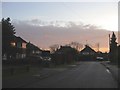
Ledgers Meadow, Cuckfield
Small cul de sac built in the 1950s off the High Street. Taken at sunrise.
Image: © Simon Carey
Taken: 29 Nov 2014
0.11 miles
9
Mytten Bank, Cuckfield
Small cul de sac containing four dwellings off Broad Street built in the 1990s in the former grounds of Mytten House which was once a field, according to Cuckfield's 1843 tithe map, called Mittens Field.
Image: © Simon Carey
Taken: 20 Dec 2014
0.12 miles
10
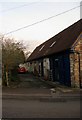
Rose and Crown Mews, London Lane, Cuckfield
What looks like former stables for the old inn have been converted into either dwellings or small business units.
Image: © Simon Carey
Taken: 20 Dec 2014
0.13 miles