IMAGES TAKEN NEAR TO
Buttinghill Drive, HAYWARDS HEATH, RH17 5GQ
Introduction
This page details the photographs taken nearby to Buttinghill Drive, RH17 5GQ by members of the Geograph project.
The Geograph project started in 2005 with the aim of publishing, organising and preserving representative images for every square kilometre of Great Britain, Ireland and the Isle of Man.

There are currently over 7.5m images from over14,400 individuals and you can help contribute to the project by visiting https://www.geograph.org.uk
Image Map
Images are licensed for reuse under creativecommons.org/licenses/by-sa/2.0
Notes
- Clicking on the map will re-center to the selected point.
- The higher the marker number, the further away the image location is from the centre of the postcode.
Image Listing (56 Images Found)
Images are licensed for reuse under creativecommons.org/licenses/by-sa/2.0
Image
Details
Distance
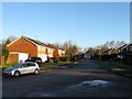
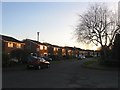
1
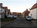
Buttinghill Drive, Cuckfield
Brand new development that began in 2013 with some homes yet to be completed at the beginning of 2015. It occupies an old field called Crouch Land according to Cuckfield's 1843 tithe map. The new development is accessed via Bylanes Close.
Image: © Simon Carey
Taken: 24 Jan 2015
0.03 miles
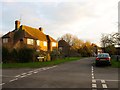
3
Bylanes Crescent, Cuckfield
Image: © Simon Carey
Taken: 17 Feb 2015
0.07 miles
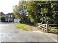
4
The old hospital at CUCKFIELD
The former hospital premises closed several years ago and now provide private housing.
Image: © Nigel Freeman
Taken: 26 Jun 2005
0.08 miles
5
Bylanes Close, Cuckfield
Part of a small estate built in the 1970s which also contains Image and Image on former fields called Pit Meadow and Great Meadow according to Cuckfield's 1843 tithe map. Another new development Image is being built to the north with this road providing access.
Image: © Simon Carey
Taken: 17 Feb 2015
0.08 miles
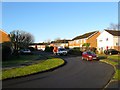
6
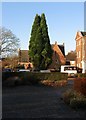
The Old Chapel, Chapelfields, Cuckfield
Built in 1858 as a chapel for the old workhouse that later became Cuckfield Hospital, see Image I think it has been converted into a residence.
Image: © Simon Carey
Taken: 17 Feb 2015
0.08 miles
7
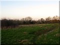
The Green Field
The name of the field according to Cuckfield's 1843 tithe map that is located to the west of Image
Image: © Simon Carey
Taken: 24 Jan 2015
0.08 miles
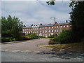
8
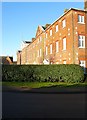
The Old Hospital, Chapelfields, Cuckfield
Built in 1843 as a workhouse to replace Image it became a hospital between the wars being given over to the Canadian Army during the Second World War and became part of the National Health Service in 1947. The hospital closed in 1991 with all its services transferred to the Princess Royal in Haywards Heath. The main administrative block has now been converted into flats whilst Image and the old lodges fronting Ardingly Road have also survived, the rest, however, have been demolished and turned into a residential estate. Prior to the construction of the workhouse this was an open field called Old Meadow according to Cuckfield's 1843 tithe map.
Image: © Simon Carey
Taken: 17 Feb 2015
0.10 miles
9
Woodhall Close, Cuckfield
Part of a residential estate built in the early 1970s with this road occupying the area that once contained Little meadow according to Cuckfield's 1843 tithe map.
Image: © Simon Carey
Taken: 24 Jan 2015
0.10 miles
10
Brainsmead Close (1), Cuckfield
This part of the road lies to the east of Brainsmead and is clearly laid out on both the 1937 OS map and a 1947 aerial photograph. However, the houses were not added until after the latter first appearing on the 1956 OS edition. See also Image
Image: © Simon Carey
Taken: 20 Dec 2014
0.11 miles