IMAGES TAKEN NEAR TO
Brainsmead, HAYWARDS HEATH, RH17 5EY
Introduction
This page details the photographs taken nearby to Brainsmead, RH17 5EY by members of the Geograph project.
The Geograph project started in 2005 with the aim of publishing, organising and preserving representative images for every square kilometre of Great Britain, Ireland and the Isle of Man.

There are currently over 7.5m images from over14,400 individuals and you can help contribute to the project by visiting https://www.geograph.org.uk
Image Map
Images are licensed for reuse under creativecommons.org/licenses/by-sa/2.0
Notes
- Clicking on the map will re-center to the selected point.
- The higher the marker number, the further away the image location is from the centre of the postcode.
Image Listing (67 Images Found)
Images are licensed for reuse under creativecommons.org/licenses/by-sa/2.0
Image
Details
Distance
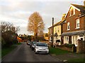
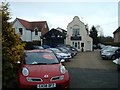
1
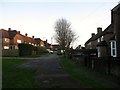
Brainsmead, Cuckfield
The northern part of the road, see Image for the southern portion. The western side was completed before the Second World War whilst the eastern side was added in the 1950s.
Image: © Simon Carey
Taken: 24 Jan 2015
0.00 miles
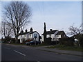
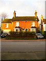
2
Brainsmead Cottages, London Road, Whitemans Green
Three cottages that were originally one building, numbers 1 and 2 date from the 1480s built as a hall house with number 3 added as an extension in the 1680s. One of the oldest secular buildings in Cuckfield.
Image: © Simon Carey
Taken: 6 Dec 2014
0.04 miles
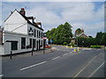
3
Whiteman's Green, Cuckfield
The blue sign says Cuckfield on it
Image: © David Howard
Taken: 7 Apr 2013
0.04 miles
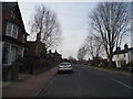
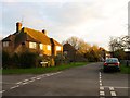
5
Brainsmead Close (2), Cuckfield
The older section of the close, see Image, that lies between Brainsmead and London Road. Number 2, the yellow faced cottage, was built in the late Victorian period with the others 1, 3 and 4 arriving between 1897 and 1911. At the end of the road is Image
Image: © Simon Carey
Taken: 20 Dec 2014
0.04 miles
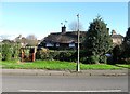
6
Whiteman's Green and the Ship
The Ship Inn serves good food. Whiteman's Green to many people in the locale means the large playing field area not far from this pub.
Image: © Nigel Freeman
Taken: 26 Jun 2005
0.05 miles
7
Brainsmead Close (1), Cuckfield
This part of the road lies to the east of Brainsmead and is clearly laid out on both the 1937 OS map and a 1947 aerial photograph. However, the houses were not added until after the latter first appearing on the 1956 OS edition. See also Image
Image: © Simon Carey
Taken: 20 Dec 2014
0.05 miles
8
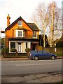
Allenby House, London Road, Whitemans Green
Built in the victorian period as a shop and dwelling though the former has long since gone though it retains the former shop front.
Image: © Simon Carey
Taken: 20 Dec 2014
0.05 miles
9
Car dealer, Whitemans Green, Cuckfield
Image: © Stacey Harris
Taken: 23 Jan 2010
0.06 miles
10
Woodcroft Villas, London Road, Whitemans Green
A pair of semi-detached houses built during the late 19th century on the western side of the road.
Image: © Simon Carey
Taken: 20 Dec 2014
0.06 miles