IMAGES TAKEN NEAR TO
Talfourd Way, REDHILL, RH1 6GD
Introduction
This page details the photographs taken nearby to Talfourd Way, RH1 6GD by members of the Geograph project.
The Geograph project started in 2005 with the aim of publishing, organising and preserving representative images for every square kilometre of Great Britain, Ireland and the Isle of Man.

There are currently over 7.5m images from over14,400 individuals and you can help contribute to the project by visiting https://www.geograph.org.uk
Image Map
Images are licensed for reuse under creativecommons.org/licenses/by-sa/2.0
Notes
- Clicking on the map will re-center to the selected point.
- The higher the marker number, the further away the image location is from the centre of the postcode.
Image Listing (63 Images Found)
Images are licensed for reuse under creativecommons.org/licenses/by-sa/2.0
Image
Details
Distance
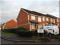
1
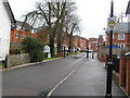
Former Royal Earlswood Hospital
Now a housing development & gated community
Image: © N Chadwick
Taken: 15 Jan 2006
0.03 miles
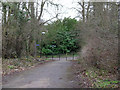
2
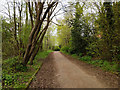
Foot and cycle path towards Earlswood
From East Surrey Hospital and beyond. This section of the path was formerly one of the roads associated with the large mental hospital once here. After this was converted to up-market residential units it became redundant, and is blanked off from the grounds some way behind the camera.
Image: © Robin Webster
Taken: 21 Apr 2018
0.03 miles
3
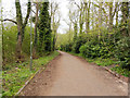
Foot and cycle path towards Earlswood
From East Surrey Hospital and beyond. This section of the path was formerly one of the roads associated with the large mental hospital once here. After this was converted to residential units it became redundant, and is blanked off behind the camera.
Image: © Robin Webster
Taken: 21 Apr 2018
0.05 miles
4
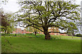
A glimpse of Royal Earlswood Park
A former mental hospital, now converted to an up-market residential estate.
Image: © Robin Webster
Taken: 21 Apr 2018
0.05 miles
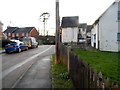
5
New houses on Asylum Arch Road, Earlswood
Image: © David Howard
Taken: 31 Jan 2016
0.05 miles
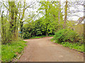
6
Footpath junction by former hospital
The ways here were formerly roads associated with the Royal Earlswood Hospital. This huge mental hospital closed and is now a residential area, but these old roads are not used for vehicle access.
Image: © Robin Webster
Taken: 25 Mar 2010
0.06 miles
8
Path junction by Royal Earlswood Park
The paths here were formerly roads associated with the large mental hospital once here. This, which is to the right here, has been converted into up-market residential units.
Image: © Robin Webster
Taken: 21 Apr 2018
0.07 miles
9
Royal Earlswood Children's Nursery, Asylum Arch Road
Image: © David Howard
Taken: 31 Jan 2016
0.07 miles
10
New houses on Asylum Arch Road, Earlswood
This estate replaced the old Earlswood mental asylum
Image: © David Howard
Taken: 31 Jan 2016
0.07 miles