IMAGES TAKEN NEAR TO
Renfields, HAYWARDS HEATH, RH16 4TG
Introduction
This page details the photographs taken nearby to Renfields, RH16 4TG by members of the Geograph project.
The Geograph project started in 2005 with the aim of publishing, organising and preserving representative images for every square kilometre of Great Britain, Ireland and the Isle of Man.

There are currently over 7.5m images from over14,400 individuals and you can help contribute to the project by visiting https://www.geograph.org.uk
Image Map
Images are licensed for reuse under creativecommons.org/licenses/by-sa/2.0
Notes
- Clicking on the map will re-center to the selected point.
- The higher the marker number, the further away the image location is from the centre of the postcode.
Image Listing (67 Images Found)
Images are licensed for reuse under creativecommons.org/licenses/by-sa/2.0
Image
Details
Distance
1
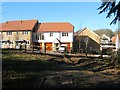
New Development, Bolnore Village
Located to the immediate north of Image Bolnore village is a completely new development in the south western corner of Haywards Heath that includes the construction of 851 homes in what is a new community. The development began around 2001 and included the new relief road for the town.
Image: © Simon Carey
Taken: 17 Feb 2015
0.02 miles
2
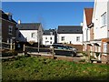
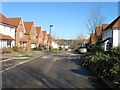
Renfields, Bolnore Village
Part of the new development began in 2001 that will eventually include 851 new homes on the south western corner of Haywards Heath.
Image: © Simon Carey
Taken: 17 Feb 2015
0.03 miles
3
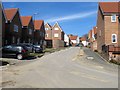
Chandlers Field Drive, Bolnore Village
Recently completed part of the Bolnore development which has yet to appear on any OS map so the map references are a rough guess. According to Cuckfield's 1843 tithe map this road occupies a former field called Lower Eight Acres.
Image: © Simon Carey
Taken: 7 Mar 2015
0.06 miles
4
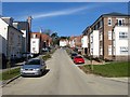
Trubwick Avenue, Bolnore Village
Part of a recently completed part of the Bolnore development linking Parkfield Way to Renfields.
Image: © Simon Carey
Taken: 7 Mar 2015
0.06 miles
5
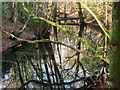
Quarry Hollow
A former quarry now a long thin pond squeezed between the bridleway and the new Bolnore development.
Image: © Simon Carey
Taken: 17 Feb 2015
0.07 miles
6
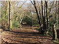
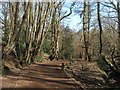
Bridleway, Ashenground Wood
Marked on a 1638 estate map as being part of the King's highway and called Half Streete Lane with the road linking Isaac's Lane with what is now Wivelsfield Road. To the east of the railway the highway has become Ashenground Road whilst the section to the west became a bridleway though since the development of Bolnore Village around it the route has been given a hard surface. This section of the lane once formed part of the parish boundary between Cuckfield and Keymer.
Image: © Simon Carey
Taken: 17 Feb 2015
0.07 miles
8
Renfields, Bolnore Village
A completed section of the new development that includes 851 homes in the south west corner of Haywards Heath. Once a field called Furze Hill according to Cuckfield's 1843 tithe map.
Image: © Simon Carey
Taken: 17 Feb 2015
0.08 miles
9
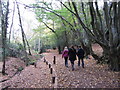
Bridleway, Ashenground Park
The bridleway is a very old route which is clearly marked on a 1638 estate map with this section forming the old parish boundary between Cuckfield to the north and Keymer to the south. Now part of the Ashenground Park nature reserve that is located in the rump of the old woodland that lies between the new Bolnore village development and the railway. One of the consequences is the bridleway has been given a hard surface.
Image: © Simon Carey
Taken: 7 Mar 2015
0.08 miles
10
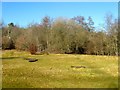
Four Acre Wood
An open area within the woodland that will not be developed as it was discovered the wood was ancient woodland.
Image: © Simon Carey
Taken: 17 Feb 2015
0.09 miles