IMAGES TAKEN NEAR TO
Isaacs Lane, HAYWARDS HEATH, RH16 4SA
Introduction
This page details the photographs taken nearby to Isaacs Lane, RH16 4SA by members of the Geograph project.
The Geograph project started in 2005 with the aim of publishing, organising and preserving representative images for every square kilometre of Great Britain, Ireland and the Isle of Man.

There are currently over 7.5m images from over14,400 individuals and you can help contribute to the project by visiting https://www.geograph.org.uk
Image Map
Images are licensed for reuse under creativecommons.org/licenses/by-sa/2.0
Notes
- Clicking on the map will re-center to the selected point.
- The higher the marker number, the further away the image location is from the centre of the postcode.
Image Listing (14 Images Found)
Images are licensed for reuse under creativecommons.org/licenses/by-sa/2.0
Image
Details
Distance
1
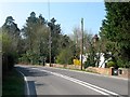
Ironpeartree Cottages, Isaac's Lane
Originally a single dwelling called Ironpeartree that has been subdivided into three cottages. The building dates from the 17th century.
Image: © Simon Carey
Taken: 9 Apr 2015
0.00 miles
3
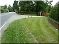
Gateway to Heaselands
Off the A273 Isaac's Lane.
Image: © Dave Spicer
Taken: 15 May 2011
0.06 miles
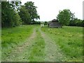
5
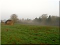
Upper Well Croft
The name of the field according to Cuckfield's 1843 tithe map that lies to the east of Image, west of Image and north of Stonepit Cottage and Stonepit Plantation. The run down barn first appears on the 1937 OS map.
Image: © Simon Carey
Taken: 9 Apr 2015
0.12 miles
6
Pear Tree Cottages, Isaac's Lane
Originally known as Ironpeartree Cottages after a house of the same name a little to the south, the pair on the left were built in the last quarter of the 19th century whilst the timber framed pair beyond were built much earlier during the same century. They had acquired the current name by the 1950s.
Image: © Simon Carey
Taken: 9 Apr 2015
0.12 miles
7
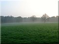
Lower Saunders
The name of the field according to Cuckfield's 1843 tithe map that has been extended to include Image to the east, with the three trees visible through the early morning mist being the remnant of the former field boundary between the two. The field is bounded by Image to the west, Copyhold Gill to the north and Isaac's Lane to the south. Part of the field next to the latter has been lost to Image
Image: © Simon Carey
Taken: 9 Apr 2015
0.13 miles
8
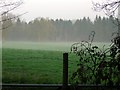
Upper Saunders
The name of the field according to Cuckfield's 1843 tithe map that has been extended to include Image to the west. Viewed from Isaac's Lane with Copyhold Gill the wood at the end of the field.
Image: © Simon Carey
Taken: 9 Apr 2015
0.18 miles
9
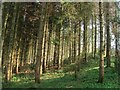
Copyhold Gill
A wood that lines the slopes of an unnamed stream though this part has more of a plantation feel to it.
Image: © Simon Carey
Taken: 9 Apr 2015
0.18 miles
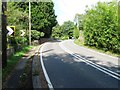
10
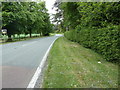
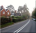
A273 Isaac's Lane south from Haywards Heath
Image: © Dave Spicer
Taken: 15 May 2011
0.19 miles