IMAGES TAKEN NEAR TO
Franklynn Road, HAYWARDS HEATH, RH16 4DR
Introduction
This page details the photographs taken nearby to Franklynn Road, RH16 4DR by members of the Geograph project.
The Geograph project started in 2005 with the aim of publishing, organising and preserving representative images for every square kilometre of Great Britain, Ireland and the Isle of Man.

There are currently over 7.5m images from over14,400 individuals and you can help contribute to the project by visiting https://www.geograph.org.uk
Image Map
Images are licensed for reuse under creativecommons.org/licenses/by-sa/2.0
Notes
- Clicking on the map will re-center to the selected point.
- The higher the marker number, the further away the image location is from the centre of the postcode.
Image Listing (73 Images Found)
Images are licensed for reuse under creativecommons.org/licenses/by-sa/2.0
Image
Details
Distance
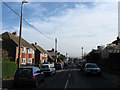
1
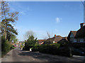
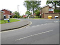
Franklynn Road
The A272 heading towards the centre of Haywards Heath. The road predates the construction of the town originally crossing a large common that was barren heathland. Until 1934 it was also the parish boundary between Wivelsfield on the left and Cuckfield to the right. At present it is very congested during the rush hour something that should be alleviated by the completion of the relief road sometime around 2015.
This area of Haywards Heath was once part of Wivelsfield parish.
Image: © Simon Carey
Taken: 10 Apr 2011
0.01 miles
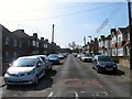
2
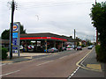
Franklynn Garage, Franklynn Road
The large garage was constructed in the late 1970s on the site of an older one based in a cottage. The main building to the right replaced a number of small cottages that stood on the spot one being a small newsagents. Franklynn Road is the main A272 eastbound route out of Haywards Heath.
Image: © Simon Carey
Taken: 30 Aug 2007
0.04 miles
4
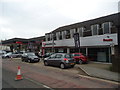
Highlands Road
Linking Lowfield Road to Colwell Road.
Image: © Simon Carey
Taken: 30 Aug 2007
0.05 miles
5
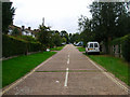
Dellney Avenue
Residential road linking Franklynn Road with Victoria Road. The foreground was originally the site of Petlands Farm which was swallowed by the development of Haywards Heath just after the First World War. The different style of houses on the left are due to the differing development, those further down were constructed before the Second World War, those immediately to the left were built after.
Image: © Simon Carey
Taken: 10 Apr 2011
0.07 miles
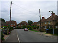
6
Dellney Avenue, Haywards Heath
A residential road that runs from Farnklynn's Road to Victoria Road that was originally a field called Barn Mead belonging to nearby Petlands Farm. By 1910 it had become a brick field to the north and allotments to the south prior to its development during the 1920s. However, the southern part on the site of the old farm was not developed until the 1960s whilst its northern connection with Victoria Road was not added until the 1950s.
Image: © Simon Carey
Taken: 7 Apr 2015
0.07 miles
7
Lowfield Road
The houses to the right were completed in the late 1940s whilst the bungalows to the left were constructed a little later. The road was until the late 1980s a private road and thus unmade. Taken from the junction with Highlands Road.
Image: © Simon Carey
Taken: 30 Aug 2007
0.08 miles
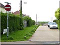
10
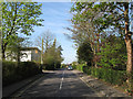
Colwell Road
Running between Lewes Road, the A272, and Fox Hill, the B2112, the route predates the construction of the town of Haywards Heath, originally forming the southern boundary of Otehall Common, the name of the Wivelsfield portion of the large common known as Haywards Heath. When the County Lunatic Asylum, later St Francis Hospital, was constructed in 1859 it was given the name, Asylum Road, which it retained until changing to its current name after the First World War.
This area of Haywards Heath was originally part of Wivelsfield parish until 1934.
Image: © Simon Carey
Taken: 10 Apr 2011
0.10 miles