IMAGES TAKEN NEAR TO
Wealden Way, HAYWARDS HEATH, RH16 4DD
Introduction
This page details the photographs taken nearby to Wealden Way, RH16 4DD by members of the Geograph project.
The Geograph project started in 2005 with the aim of publishing, organising and preserving representative images for every square kilometre of Great Britain, Ireland and the Isle of Man.

There are currently over 7.5m images from over14,400 individuals and you can help contribute to the project by visiting https://www.geograph.org.uk
Image Map
Images are licensed for reuse under creativecommons.org/licenses/by-sa/2.0
Notes
- Clicking on the map will re-center to the selected point.
- The higher the marker number, the further away the image location is from the centre of the postcode.
Image Listing (56 Images Found)
Images are licensed for reuse under creativecommons.org/licenses/by-sa/2.0
Image
Details
Distance
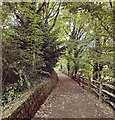
1
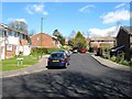
Wealden Way, Haywards Heath
Built in the 1970s on fields formerly belonging to Great Haywards Farm, whose 16th century farmhouse still stands in grounds beyond the trees to the left. This is the southern end of the road which is accessed via Bolnore Road.
Image: © Simon Carey
Taken: 7 Mar 2015
0.02 miles
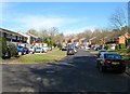
2
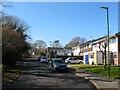
Drummond Close, Haywards Heath
A cul de sac off Sunnywood Drive that also has pedestrian access to Victoria Park which is located to the immediate north. Built in the 1980s in the grounds of a large house built between the wars.
Image: © Simon Carey
Taken: 17 Feb 2015
0.07 miles
3
Great Haywards, Haywards Heath
Amongst a late 1970s housing estate is this former farmhouse dating back to the 15th century and originally the main house for the manor of Hayworth. Viewed from Wealden Way.
Image: © Simon Carey
Taken: 31 Mar 2015
0.07 miles
4
Duncton Close, Haywards Heath
A small cul de sac off Climping Close built in the late 1970s on former fields belonging to Great Haywards Farm.
Image: © Simon Carey
Taken: 31 Mar 2015
0.07 miles
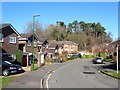
5
Climping Close, Haywards Heath
A cul de sac off Wealden Way that was built in the 1970s on a former field called Lower Meadow, according to Cuckfield's 1843 tithe map, that had once belonged to Great Haywards Farm. To the south is Image which is in the process of being built on as part of the bolnore village development.
Image: © Simon Carey
Taken: 7 Mar 2015
0.09 miles
6
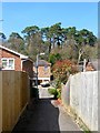
Path to Drummond Close, Haywards Heath
Linking the northern end of Sunnywood Drive to the close and then Victoria Park. Part of the park built on the former spoil heap made by the construction of the railway in 1841 can be seen beyond.
Image: © Simon Carey
Taken: 7 Apr 2015
0.10 miles
7
Woodland Between Victoria Park and the Brighton Mainline
Image: © Thoma
Taken: 29 Dec 2016
0.11 miles
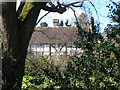
8
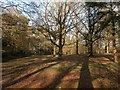
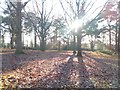
Victoria Park, Haywards Heath
This wooded section on the western side of the park lies upon a mound of earth created by the excavation of nearby Haywards Heath Tunnel on the London-Brighton railway in 1841. The mound remained in the ownership of the railway until 1863 when locals regained control and became part of Victoria Park in 1897.
Image: © Simon Carey
Taken: 8 Feb 2015
0.11 miles
9
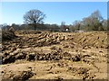
Mope Field
The name of the field according to Cuckfield's 1843 tithe map that was later merged with Image to the south and is now about to disappear under the last phase of the Bolnore village development.
Image: © Simon Carey
Taken: 7 Mar 2015
0.13 miles