IMAGES TAKEN NEAR TO
Chownes Mead Lane, HAYWARDS HEATH, RH16 4BS
Introduction
This page details the photographs taken nearby to Chownes Mead Lane, RH16 4BS by members of the Geograph project.
The Geograph project started in 2005 with the aim of publishing, organising and preserving representative images for every square kilometre of Great Britain, Ireland and the Isle of Man.

There are currently over 7.5m images from over14,400 individuals and you can help contribute to the project by visiting https://www.geograph.org.uk
Image Map
Images are licensed for reuse under creativecommons.org/licenses/by-sa/2.0
Notes
- Clicking on the map will re-center to the selected point.
- The higher the marker number, the further away the image location is from the centre of the postcode.
Image Listing (27 Images Found)
Images are licensed for reuse under creativecommons.org/licenses/by-sa/2.0
Image
Details
Distance
1
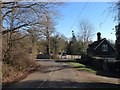
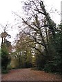
Meads Cottage, Chownes Mead Lane, Haywards Heath
Built in the late 19th century near to the junction with Isaac's Lane. Beyond is the entrance to Bolnore House.
Image: © Simon Carey
Taken: 17 Feb 2015
0.04 miles
2
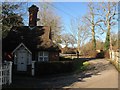
Meads Lodge, Chownes Mead Lane, Haywards Heath
Built in the last quarter of the 19th century as the entrance lodge to a house called The Meads.
Image: © Simon Carey
Taken: 17 Feb 2015
0.06 miles
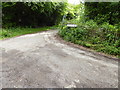
3
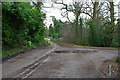
The old main road to Burgess Hill
Replaced by realigned roads, this road comes to an end with the new road in sight. A turning bay is on the right. It has been retained with access from the other end to serve a few premises.
Image: © Robin Webster
Taken: 14 Mar 2010
0.07 miles
4
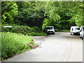
The dead end of Isaac's Lane
See also http://www.geograph.org.uk/photo/1753088 from 2010.
Image: © Shazz
Taken: 20 May 2016
0.08 miles
7
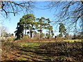
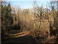
Dutch Barn Field
The name of the field according to Cuckfield's 1843 tithe map that was originally bounded by Tyler's Green, the A272, to the north, Isaac's Lane, the A273, and The Paddocks to the east, Chownes Mead Lane to the south. Part of the field was lost when Isaac's Lane was rerouted to the west of The Paddocks in the 1990s.
Image: © Simon Carey
Taken: 17 Feb 2015
0.10 miles
8
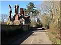
Coach House, Chownes Mead Lane, Haywards Heath
Built just after the First World War as the coach house for Chownes Mead, a faux Jacobean country house built on the site of a former farm called Chownes by banker Sir Alexander Kleinwort. Chownes Mead Lane was originally known as Chownes Road and is an old route linking Tylers Green to Isaac's Lane and is marked as such on a 1638 estate map. Later it became the B2164 until Isaac's Lane was rerouted and the western send at Tyler's Green is now closed.
Image: © Simon Carey
Taken: 17 Feb 2015
0.11 miles
9
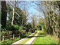
Old Furze Field
The name of the field according to Cuckfield's 1843 tithe map that lies to the west of the old course of Isaac's Lane that is now a cycle and footpath.
Image: © Simon Carey
Taken: 17 Feb 2015
0.12 miles
10
Bolnore Farm Lane, Haywards Heath
Viewed from the junction with Bolnore Road and looking towards its terminus at Isaac's Lane. The track serves Bolnore Farm and a number of other dwellings and is of some antiquity having been marked on a 1638 estate map and given the name Half Streete Lane.
Image: © Simon Carey
Taken: 12 Apr 2015
0.14 miles