IMAGES TAKEN NEAR TO
Vermont Place, HAYWARDS HEATH, RH16 3UW
Introduction
This page details the photographs taken nearby to Vermont Place, RH16 3UW by members of the Geograph project.
The Geograph project started in 2005 with the aim of publishing, organising and preserving representative images for every square kilometre of Great Britain, Ireland and the Isle of Man.

There are currently over 7.5m images from over14,400 individuals and you can help contribute to the project by visiting https://www.geograph.org.uk
Image Map (Loading...)


Getting Data...Please wait
Leaflet Map data © OpenStreetMap
Images are licensed for reuse under creativecommons.org/licenses/by-sa/2.0
Notes
- Clicking on the map will re-center to the selected point.
- The higher the marker number, the further away the image location is from the centre of the postcode.
Image Listing (62 Images Found)
Images are licensed for reuse under creativecommons.org/licenses/by-sa/2.0
Image
Details
Distance
1
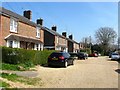
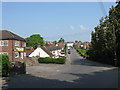
Windermere Road, Haywards Heath
A private cul de sac now found at the eastern end of Woodlands Road, however, it predates that road and was originally accessed via New England Road though that route is little more than a footpath today. The northern side was built in the first decade of the 20th century on a former brick field which had been excavated to provide for houses on New England Road. The houses to the south, out of shot to the right were added intermittently from the 1940s onwards.
Image: © Simon Carey
Taken: 7 Apr 2015
0.04 miles
2
Auckland Place, Western Road, Haywards Heath
Originally a builders yard that was converted into an office block called Progress House in the 1970s. The block was empty when I last passed this way, see Image, and during 2014 was converted into flats.
Image: © Simon Carey
Taken: 30 Mar 2015
0.06 miles
3
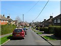
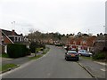
Woodlands Road, Haywards Heath
Looking eastwards from the junction with Mayflower Road, the initial three houses on either side date from the 1920s when the road was originally laid out, those beyond were added in the late 1950s when the road was extended to Windermere Road. Prior to that much of the area was the original site of Haywards Heath's first sewage farm which by 1910 has become allotments. The eastern end of the road is built on the site of a former brick field. The woodlands in the name would have been an acknowledgement of nearby Petlands Wood and Bent's Wood both of which have been lost to development.
Image: © Simon Carey
Taken: 7 Apr 2015
0.06 miles
4
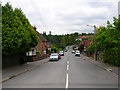
Western Road
Linking New England Road with Franklynn Road (A272). Laid out through Petlands Wood in the 1920s and gradually built up over the next 30 years. The dip in the road marks the entry to the towns cemetery.
Image: © Simon Carey
Taken: 30 Aug 2007
0.06 miles
5
Western Road
Opposite view of Image looking up towards the junction with New England Road. Like the surrounding roads it was laid out before the First World War but not developed until after. The empty office block on the left, Progress House, was built on the site of a builders yard.
Image: © Simon Carey
Taken: 30 Apr 2011
0.07 miles
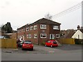
6
Priory Way, Haywards Heath
Once part of Petland Wood which covered an area now containing Haywards Heath cemetery, Western Road, Eastern Road, North Road and Victoria Road. This part remained undeveloped until the 1970s when this estate was built which was later extended southwards into the former grounds of the Priory.
Image: © Simon Carey
Taken: 30 Mar 2015
0.07 miles
7
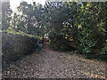
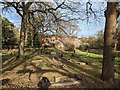
Haywards Heath Cemetery - Perimeter Nature Walk
A strip of land along the stream is fenced off from the cemetery itself to the left and contains the 'Perimeter Nature Walk'. There are steps up to Western Road at this western end.
Image: © Robin Webster
Taken: 19 Feb 2023
0.07 miles
9
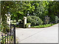
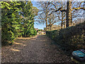
In Haywards Heath Cemetery
Section BC in the foreground, according to a plan at the entrance. The section identification letters are presumably to some logical system, but it is far from obvious what it is.
Image: © Robin Webster
Taken: 19 Feb 2023
0.09 miles
10
Haywards Heath Cemetery - Perimeter Nature Walk
A strip of land along a stream is fenced off from the cemetery itself and contains the 'Perimeter Nature Walk'. This narrow part broadens out somewhat around the corner.
Image: © Robin Webster
Taken: 19 Feb 2023
0.10 miles