IMAGES TAKEN NEAR TO
Franklands Village, HAYWARDS HEATH, RH16 3RP
Introduction
This page details the photographs taken nearby to Franklands Village, RH16 3RP by members of the Geograph project.
The Geograph project started in 2005 with the aim of publishing, organising and preserving representative images for every square kilometre of Great Britain, Ireland and the Isle of Man.

There are currently over 7.5m images from over14,400 individuals and you can help contribute to the project by visiting https://www.geograph.org.uk
Image Map
Images are licensed for reuse under creativecommons.org/licenses/by-sa/2.0
Notes
- Clicking on the map will re-center to the selected point.
- The higher the marker number, the further away the image location is from the centre of the postcode.
Image Listing (45 Images Found)
Images are licensed for reuse under creativecommons.org/licenses/by-sa/2.0
Image
Details
Distance
1
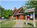
Church of the Good Shepherd, Franklands Village
Built in the mid 1960s to serve the growing community of Franklands Village.
Franklands Village is a model village built in the 1930s in order to create housing for a fair economic rent. Built on the site of Franklands Wood, which was originally part of the parish of Wivelsfield until transferred to Haywards Heath in 1934, the community consists of two roads, Graveleye Lane, on the right, which runs south to north, and Reed Pond Walk, on the left, which loops around in semi circle rejoining Graveleye Lane further up. Facilities include a purpose built shop, a large village hall, a playing field and a church. The Franklands Village Housing Association still let a considerable number of houses today all of which have their own gardens.
Image: © Simon Carey
Taken: 30 Apr 2011
0.05 miles
2
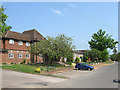
Franklands Village Hall
The social hub of the village which includes a social club and facilities for a variety of groups to meet. Beyond is the estate office which is home to the Franklands Village Housing Association.
Franklands Village is a model village built in the 1930s in order to create housing for a fair economic rent. Built on the site of Franklands Wood, which was originally part of the parish of Wivelsfield until transferred to Haywards Heath in 1934, the community consists of two roads, Graveleye Lane, on the right, which runs south to north, and Reed Pond Walk, on the left, which loops around in semi circle rejoining Graveleye Lane further up. Facilities include a purpose built shop, a large village hall, a playing field and a church. The Franklands Village Housing Association still let a considerable number of houses today all of which have their own gardens.
Image: © Simon Carey
Taken: 30 Apr 2011
0.05 miles
3
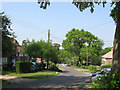
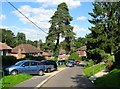
Reed Pond Walk, Franklands Village
Viewed from the northern junction with Graveleye Lane.
Franklands Village is a model village built in the 1930s in order to create housing for a fair economic rent. Built on the site of Franklands Wood, which was originally part of the parish of Wivelsfield until transferred to Haywards Heath in 1934, the community consists of two roads, Graveleye Lane, on the right, which runs south to north, and Reed Pond Walk, on the left, which loops around in semi circle rejoining Graveleye Lane further up. Facilities include a purpose built shop, a large village hall, a playing field and a church. The Franklands Village Housing Association still let a considerable number of houses today all of which have their own gardens.
Image: © Simon Carey
Taken: 30 Apr 2011
0.08 miles
4
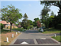
Graveleye Lane, Franklands Village
Looking northwards towards the junction with Reed Pond Lane.
Franklands Village is a model village built in the 1930s in order to create housing for a fair economic rent. Built on the site of Franklands Wood, which was originally part of the parish of Wivelsfield until transferred to Haywards Heath in 1934, the community consists of two roads, Graveleye Lane, on the right, which runs south to north, and Reed Pond Walk, on the left, which loops around in semi circle rejoining Graveleye Lane further up. Facilities include a purpose built shop, a large village hall, a playing field and a church. The Franklands Village Housing Association still let a considerable number of houses today all of which have their own gardens.
Image: © Simon Carey
Taken: 30 Apr 2011
0.09 miles
5
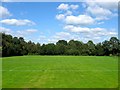
Hardy Memorial Playing Field, Franklands Village
The main recreational playing area in Franklands Village located to the rear of the village hall. It is also home to Franklands Village FC who were formed in 1956 and joined Sussex County Division Three in 1983 where they largely stayed until resigning from the league in 2004 having been forced to move away from the ground due to a change in FA ground rules. They have now returned and play in the Mid Sussex League.
Image: © Simon Carey
Taken: 6 Sep 2015
0.10 miles
6
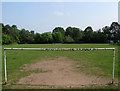
Hardy Memorial Playing Field
The main recreational playing area in Franklands Village located to the rear of the village hall. It is also home to Franklands Village FC who were formed in 1956 and joined Sussex County Division Three in 1983 where they largely stayed until resigning from the league in 2004 having been forced to move away from the ground due to a change in FA ground rules. They have now returned and play in the Mid Sussex League.
Franklands Village is a model village built in the 1930s in order to create housing for a fair economic rent. Built on the site of Franklands Wood, which was originally part of the parish of Wivelsfield until transferred to Haywards Heath in 1934, the community consists of two roads, Graveleye Lane, on the right, which runs south to north, and Reed Pond Walk, on the left, which loops around in semi circle rejoining Graveleye Lane further up. Facilities include a purpose built shop, a large village hall, a playing field and a church. The Franklands Village Housing Association still let a considerable number of houses today all of which have their own gardens.
Image: © Simon Carey
Taken: 30 Apr 2011
0.11 miles
7
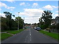
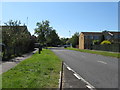
Northlands Avenue, Haywards Heath
The main access route for Franklands Village and the Northlands estate built along with the latter in the 1970s as part of the Northlands estate on the site of Northlands Wood that had originally been part of the parish of Wivelsfield but was transferred to Haywards Heath in 1934. The road begins as Frankton Avenue on the B2272 becoming Northlands Avenue at the junction with Gravelye Lane at the entrance to Franklands Village rejoining that road over the parish boundary with Lindfield. The sewer vent pipe on the right also marks the location of Northlands Brook now culverted and part of the sewer system of the estate.
Image: © Simon Carey
Taken: 6 Sep 2015
0.13 miles
8
Silver Birches, Haywards Heath
A small housing estate originally located between Image and Reed Pond Walk though access via the latter has now been closed. Built in the 1970son a northern remnant of Franklands Wood.
Image: © Simon Carey
Taken: 6 Sep 2015
0.13 miles
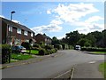
9
Northlands Avenue passing through Franklands Village
Franklands Village is a suburb of Haywards Heath.
Image: © Dave Spicer
Taken: 7 Sep 2012
0.13 miles
10
Reed Pond Walk, Franklands Village
Franklands Village is a model village built in the 1930s in order to create housing for a fair economic rent. Built on the site of Franklands Wood, which was originally part of the parish of Wivelsfield until transferred to Haywards Heath in 1934, the community consists of two roads, Graveleye Lane, to the east, which runs south to north, and Reed Pond Walk, to the west, which loops around in semi circle rejoining Graveleye Lane further up. Facilities include a purpose built shop, a large village hall, a playing field and a church. The Franklands Village Housing Association still let a considerable number of houses today all of which have their own gardens. This section of Reed Pond Walk was one of the last to be completed in 1938.
Image: © Simon Carey
Taken: 6 Sep 2015
0.13 miles