IMAGES TAKEN NEAR TO
Eastern Road, HAYWARDS HEATH, RH16 3NQ
Introduction
This page details the photographs taken nearby to Eastern Road, RH16 3NQ by members of the Geograph project.
The Geograph project started in 2005 with the aim of publishing, organising and preserving representative images for every square kilometre of Great Britain, Ireland and the Isle of Man.

There are currently over 7.5m images from over14,400 individuals and you can help contribute to the project by visiting https://www.geograph.org.uk
Image Map
Images are licensed for reuse under creativecommons.org/licenses/by-sa/2.0
Notes
- Clicking on the map will re-center to the selected point.
- The higher the marker number, the further away the image location is from the centre of the postcode.
Image Listing (51 Images Found)
Images are licensed for reuse under creativecommons.org/licenses/by-sa/2.0
Image
Details
Distance
1
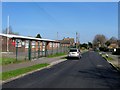
Army Cadets Training Centre, Eastern Road, Haywards Heath
Built in the mid 1960s to replace the old drill hall that was located at the cattle market. Beyond is Image
Image: © Simon Carey
Taken: 7 Apr 2015
0.03 miles
2
St Wilfred's CofE Primary School
In Eastern Road, Haywards Heath.
Image: © Robin Webster
Taken: 14 Mar 2010
0.05 miles
3
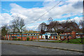
Franklynn Gospel Hall, Eastern Road, Haywards Heath
Built sometime in the 1960s for the Open Brethren and located to the immediate north of Image
Image: © Simon Carey
Taken: 7 Apr 2015
0.05 miles
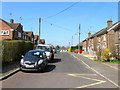
4
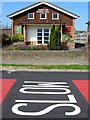
Eastern Road
Laid out before the First World War with the southern part up the hill in the distance developed during the 1920s. This part developed at a much slower pace having originally been the location of brickfields with a primary school added in the 1940s, the Eastern Road Gospel Hall on the right and neighbouring scout headquarters in the 1960s, whilst the houses on the left was still waste until the end of the 1970s when Albert Close was constructed.
Image: © Simon Carey
Taken: 30 Apr 2011
0.07 miles
5
Victoria Road, Haywards Heath
A residential road that runs east from Eastern Road before coming to a dead end. Originally part of Petlands Wood that was largely grubbed before the First World War but wasn't developed until after with the exception of the houses on the right which were built around 1910 and for a while were served by a track. Those to the left were built in the 1960s on the site of a former kitchen that served the pupils of nearby St Wilfrid's School.
Image: © Simon Carey
Taken: 7 Apr 2015
0.09 miles
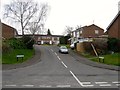
6
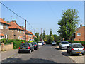
North Road
A continuation of Eastern Road as it turns west towards a junction with Western Road. The road was laid out on the site of Petlands Wood before the First World War though it was rerouted after and the houses on the left built in the 1920s. Those on the right, including a number of bungalows out of shot were not added until the 1960s.
Image: © Simon Carey
Taken: 30 Apr 2011
0.11 miles
7
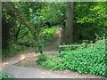
Footpath to Franklands Village
Running between Eastern Road and Reed Pond Walk the path drops down to cross a small unnamed tributary of Scrase Stream before climbing again. The stream was until 1934 the old parish boundary between Cuckfield on this side and Wivelsfield the other. The small wooded area here is the last remaining remnant of a huge swathe of woodland that was located between two former commons, Haywards Heath and Lyoth Common. Petland Wood, this side of the stream, was swallowed up the interwar expansion of Haywards Heath, Franklands Wood on the other side of the stream went in the 1930s when Franklands Village was developed and Northlands Wood disappeared in the 1970s and 80s to more housing development.
Image: © Simon Carey
Taken: 30 Apr 2011
0.12 miles
8
North Road, Haywards Heath
A residential road that runs between Western Road and Eastern Road with the southern side to the left developed in the 1920s on the site of Petlands Wood and the northern side not completed until the 1960s.
Image: © Simon Carey
Taken: 7 Apr 2015
0.13 miles
9
Rothley Chase, Haywards Heath
A small cul de sac off Priory Way that was once part of Petland Wood and was not developed until the late 1970s as part of the former grounds of the Priory.
Image: © Simon Carey
Taken: 30 Mar 2015
0.13 miles
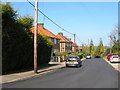
10
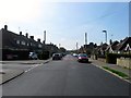
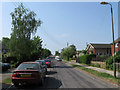
Eastern Road, Haywards Heath
A residential road connecting North Road to Franklynn Road that was laid out around 1910 and developed after the First World War, particularly the southern end, the northern part gradually being infilled after the Second World War. All the road was once part of Petlands Wood.
Image: © Simon Carey
Taken: 7 Apr 2015
0.13 miles