IMAGES TAKEN NEAR TO
Penn Crescent, HAYWARDS HEATH, RH16 3HW
Introduction
This page details the photographs taken nearby to Penn Crescent, RH16 3HW by members of the Geograph project.
The Geograph project started in 2005 with the aim of publishing, organising and preserving representative images for every square kilometre of Great Britain, Ireland and the Isle of Man.

There are currently over 7.5m images from over14,400 individuals and you can help contribute to the project by visiting https://www.geograph.org.uk
Image Map
Images are licensed for reuse under creativecommons.org/licenses/by-sa/2.0
Notes
- Clicking on the map will re-center to the selected point.
- The higher the marker number, the further away the image location is from the centre of the postcode.
Image Listing (38 Images Found)
Images are licensed for reuse under creativecommons.org/licenses/by-sa/2.0
Image
Details
Distance
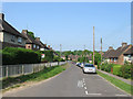
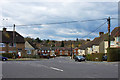
1
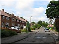
Penn Crescent, Haywards Heath
Running in a crescent shape north of Washington Road and developed sometime between 1947 and 1955 on the northern end of Bent's Wood. Most of the road names in this part of Haywards Heath, that was originally in the parish of Lindfield up to the 1930s, either have connections to America, the name given to the former smallholding settlement set up by William Allen, or quakers, which Allen was one, or indeed Allen himself. The exceptions are Barn Cottage Lane and Bentswood Crescent named after local places.
Image: © Simon Carey
Taken: 15 Aug 2015
0.06 miles
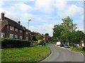
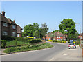
2
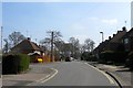
Washington Road, Haywards Heath
A continuation of Oathall Avenue until the junction with Barn Cottage Lane whereupon it changes to Hanbury Lane. The road and adjacent estates were developed in the late 1940s on the former Bent's Wood.
Image: © Simon Carey
Taken: 7 Apr 2015
0.08 miles
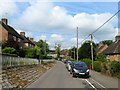
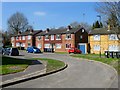
3
Little Bentswood (1), Haywards Heath
The name of the residential road that links Bentswood Road with Washington Road. This section, the northern part, was developed after the Second World War, unlike the eastern portion, see Image, that had been completed by the mid 1930s. The Bentswood estate is named after the wood it was built on.
Image: © Simon Carey
Taken: 7 Apr 2015
0.09 miles
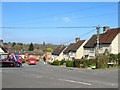
4
Bentswood Crescent, Haywards Heath
Built in the 1930s on the site of Bent's Wood and running from Bentswood Road to Barn Cottage Lane.
Image: © Simon Carey
Taken: 15 Aug 2015
0.11 miles
5
Bentswood Crescent
Built as a council estate in the 1930s on the site of Bent's Wood from which the estate got its name. The road itself links Barn Cottage Lane to Bentswood Road.
Image: © Simon Carey
Taken: 30 Apr 2011
0.12 miles
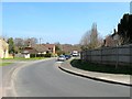
6
Washington Road, Haywards Heath
At the junction with Barn Cottage Lane, Hanbury Lane becomes Washington Road that was developed sometime between 1947 and 1955 on the northern part of Bent's Wood.
Image: © Simon Carey
Taken: 15 Aug 2015
0.13 miles
7
Little Bentswood Close, Haywards Heath
A small cul de sac off Little Bentswood that was developed in the late 1960s on the last remnant of Bent's Wood.
Image: © Simon Carey
Taken: 7 Apr 2015
0.14 miles
8
Little Bentswood (2), Haywards Heath
The eastern part of the road was built in the 1930s as part of the Bentswood Estate, with the northern part, see Image added after the Second World War. Viewed from the junction with Bentswood Road and Bentswood Crescent.
Image: © Simon Carey
Taken: 7 Apr 2015
0.14 miles
9
Little Bentswood, Haywards Heath
This is the name of the road straight ahead. Bentswood Road sweeps round from near right to left.
Image: © Robin Webster
Taken: 14 Mar 2010
0.15 miles
10
Washington Road
Along with Penn Crescent the road was developed after the Second World War on the site of Bent's Wood linking up Oathall Avenue and the junctions of Barn Cottage Lane and Hanbury Lane.
Image: © Simon Carey
Taken: 30 Apr 2011
0.15 miles