IMAGES TAKEN NEAR TO
Orchard Corner, Gravelye Lane, HAYWARDS HEATH, RH16 2RW
Introduction
This page details the photographs taken nearby to Orchard Corner, Gravelye Lane, RH16 2RW by members of the Geograph project.
The Geograph project started in 2005 with the aim of publishing, organising and preserving representative images for every square kilometre of Great Britain, Ireland and the Isle of Man.

There are currently over 7.5m images from over14,400 individuals and you can help contribute to the project by visiting https://www.geograph.org.uk
Image Map
Images are licensed for reuse under creativecommons.org/licenses/by-sa/2.0
Notes
- Clicking on the map will re-center to the selected point.
- The higher the marker number, the further away the image location is from the centre of the postcode.
Image Listing (58 Images Found)
Images are licensed for reuse under creativecommons.org/licenses/by-sa/2.0
Image
Details
Distance
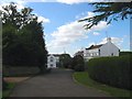
1
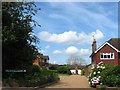
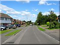
Orchard Corner, Lindfield
A small cul de sac off Gravelye Lane that was built around 1992 in the grounds of a large house, Orchard Lea, located on the right and built in 1946 on the site of a former orchard belonging to then neighbouring Gravelye Farm.
Image: © Simon Carey
Taken: 15 Aug 2015
0.01 miles
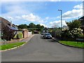
2
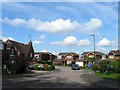
Rustlings Close, Lindfield
A small cul de sac off Gravelye Lane that stands on the site of Gravelye Farm with the farmhouse roughly located at the entrance to the close. The farm was demolished in the 1940s and replaced by the second house on the left called Rustlings. The estate itself was built in its grounds in the early 1970s.
Image: © Simon Carey
Taken: 15 Aug 2015
0.04 miles
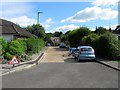
3
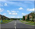
Westlands Road, Lindfield
Viewed from its junction with Gravelye Lane. Built in the early 1970s to provide access to America Lane replacing the former route which is now a bridleway.
Image: © Simon Carey
Taken: 15 Aug 2015
0.04 miles
4
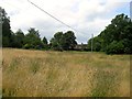
Pest House Plot
The name of the field according to Lindfield's 1845 tithe map that is located to the west of Image and Image The houses in view are on Gravelye Lane.
Image: © Simon Carey
Taken: 4 Aug 2015
0.05 miles
5
Coombers Lane, Lindfield
A cul de sac off Westlands Road that was developed in the early 1970s on a former field called Kiln Field on Lindfield's 1845 tithe map.
Image: © Simon Carey
Taken: 15 Aug 2015
0.06 miles
6
Lawrie Lane, Lindfield
Small cul de sac off Image built in the mid 1960s on a former field called Shoulder of Mutton Field according to Lindfield's 1845 tithe map.
Image: © Simon Carey
Taken: 6 Sep 2015
0.06 miles
7
Gravelye Close, Lindfield
A cul de sac off Gravelye Lane built in the grounds of Gravelye House, whose drive is on the left, in the 1990s. White Gables is the house at the far end.
Image: © Simon Carey
Taken: 6 Sep 2015
0.09 miles
8
Cripland Close, Lindfield
A small cul de sac off Image built in the early 1960s on a former field called Shoulder of Mutton Field, according to Lindfield's 1845 tithe map.
Image: © Simon Carey
Taken: 6 Sep 2015
0.09 miles
9
William Allen Lane, Lindfield
A residential road that runs from Westlands Road to the south before turning east and climbing a hill up to Gravelye Lane. For the latter section see Image Built in stages during the 1960s on a former field called Shoulder of Mutton Field according to Lindfield's 1845 tithe map.
Image: © Simon Carey
Taken: 6 Sep 2015
0.10 miles
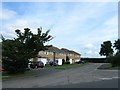
10
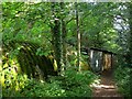
Outbuildings, Seven Acres, Gravelye Lane, Lindfield
A mish mash of styles next to the footpath that links Gravelye Lane to Walstead. They look derelict but do appear to be in use.
Image: © Simon Carey
Taken: 15 Aug 2015
0.10 miles