IMAGES TAKEN NEAR TO
Lewes Road, HAYWARDS HEATH, RH16 2LD
Introduction
This page details the photographs taken nearby to Lewes Road, RH16 2LD by members of the Geograph project.
The Geograph project started in 2005 with the aim of publishing, organising and preserving representative images for every square kilometre of Great Britain, Ireland and the Isle of Man.

There are currently over 7.5m images from over14,400 individuals and you can help contribute to the project by visiting https://www.geograph.org.uk
Image Map
Images are licensed for reuse under creativecommons.org/licenses/by-sa/2.0
Notes
- Clicking on the map will re-center to the selected point.
- The higher the marker number, the further away the image location is from the centre of the postcode.
Image Listing (141 Images Found)
Images are licensed for reuse under creativecommons.org/licenses/by-sa/2.0
Image
Details
Distance
1
Old School Court, Lindfield
A view of the old school that was built in 1878 and closed in 2000 replaced by a more modern building at the western end of the common. The school originally catered for 5-14 year olds but was became a primary school after the 1944 Education Act. Now converted into flats with the rest of the former grounds now built on, see Image The road is Lewes Road, the B2111, it straight nature owing to its former route across the common.
Image: © Simon Carey
Taken: 9 Aug 2015
0.01 miles
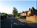
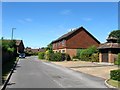
2
Lewes Road, Lindfield
Looking westwards along the B2111 from the junction with Eastern Road. The common is on the left.
Image: © Simon Carey
Taken: 9 Aug 2015
0.02 miles
3
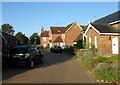
Old School Court, Lindfield
A small cul de sac developed around 2000 in the grounds of the former school, see Image The building on the right is actually the older National School Building built in 1851 and replaced by the then new building. From 1881 this became a Sunday School, a reading room and later a social centre that still used by the school up until its closure.
Image: © Simon Carey
Taken: 9 Aug 2015
0.02 miles
4
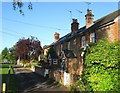
Eastern Cottages, Lewes Road, Lindfield
A row of three cottages built in the late 19th century on a path between lewes Road and the common.
Image: © Simon Carey
Taken: 4 Aug 2015
0.04 miles
5
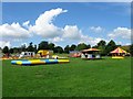
Setting up the Fair, Lindfield Common
A small children's fair is in the process of being set up on a part of the common near Lewes Road. A large number of inflatable bouncy things are waiting to be inflated.
Image: © Simon Carey
Taken: 15 Aug 2015
0.05 miles
6
Harvest Close, Lindfield
A cul de sac off Luxford Road with properties exclusively for the 55+ age range only. Built on the site of a former nursery.
Image: © Simon Carey
Taken: 9 Aug 2015
0.05 miles
7
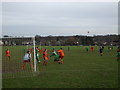
Lindfield Common - Lindfield II 1 Fairwarp 7
Foul! The camera never lies apparently as the Lindfield defender gives away a penalty. The Lindfield first team can just be seen playing in the background to the right. The common is used for cricket in summer.
Image: © nick macneill
Taken: 24 Jan 2009
0.09 miles
8
Lindfield Evangelical Free Church, Chaloner's Road, Lindfield
Originally located at Image moving to this building in 1939 where they have been ever since. Part of the County Towns Mission to begin with they changed to their current name in 1980. Chaloner's Road was developed between the wars and runs from Lewes Road to Newton Road.
Image: © Simon Carey
Taken: 4 Aug 2015
0.09 miles
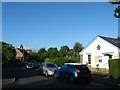
9
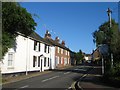
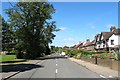
Lewes Road, Lindfield
The B2111 links the High Street in Lindfield to the A272 at Bedales Corner. The white dwellings on the left are South Malling Lodge and South Malling Cottage, whilst the small terrace beyond are Frederick Cottages which date from the Mid Victorian period.
Image: © Simon Carey
Taken: 4 Aug 2015
0.09 miles
10
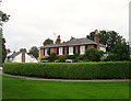
6, High Street, Lindfield
Originally called Pelham Villa but now known as Pelham House it was built in 1830 next to Lindfield Common and is the first house on the eastern side coming from the south. Beyond is Image
Image: © Simon Carey
Taken: 30 Aug 2015
0.09 miles