IMAGES TAKEN NEAR TO
High Street, HAYWARDS HEATH, RH16 2HS
Introduction
This page details the photographs taken nearby to High Street, RH16 2HS by members of the Geograph project.
The Geograph project started in 2005 with the aim of publishing, organising and preserving representative images for every square kilometre of Great Britain, Ireland and the Isle of Man.

There are currently over 7.5m images from over14,400 individuals and you can help contribute to the project by visiting https://www.geograph.org.uk
Image Map
Images are licensed for reuse under creativecommons.org/licenses/by-sa/2.0
Notes
- Clicking on the map will re-center to the selected point.
- The higher the marker number, the further away the image location is from the centre of the postcode.
Image Listing (210 Images Found)
Images are licensed for reuse under creativecommons.org/licenses/by-sa/2.0
Image
Details
Distance
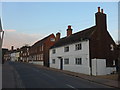
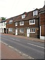
2
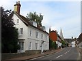
106, High Street, Lindfield
The large white building is also known as Pilstye and dates from the 17th century with an extension to the south added in the 19th. To its south is a small outbuilding that dates back to the 17th and has been used over the years as a stable, workhouse and brewery. On the left hand side are Image and Image respectively.
Image: © Simon Carey
Taken: 30 Aug 2015
0.00 miles
3
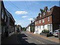
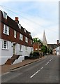
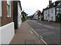
High Street, Lindfield
Looking southwards down the main village street which stretches from the church at the northern end to the former common at southern end.
Image: © Simon Carey
Taken: 18 Jul 2015
0.01 miles
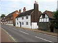
4
110, High Street, Lindfield
Also known as Pierpoint House the building dates from the 18th century with a 19th century extension to the south. Beyond is Image and Image
Image: © Simon Carey
Taken: 30 Aug 2015
0.01 miles
5
129-131, High Street, Lindfield
An early 19th century townhouse that has now been split into two cottages. Number 129 also known as Wickham House is on the left whilst 131, sometimes known as Romany Cottage, is to the right. Beyond is the southern elevation of Image whilst on the right leading up to the church are Image and Image
Image: © Simon Carey
Taken: 30 Aug 2015
0.01 miles
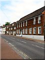
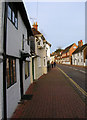
7
112-116, High Street, Lindfield
The house dates from the 17th century and was refronted in the Georgian era. Number 112 is on the right, 114 is in the middle and is also known as Oakley House, whilst 116 is to the right adjacent to Image
Image: © Simon Carey
Taken: 30 Aug 2015
0.02 miles
8
Viking Cottage, High Street, Lindfield
The northern end of the High Street near the church.
Image: © Simon Carey
Taken: 26 Jan 2008
0.02 miles
9
Looking SSW down the High Street Lindfield
Image: © Dave Spicer
Taken: 6 Jun 2009
0.02 miles
10
125, High Street, Lindfield
Also known as Froyls the house, like many others, at the top end of the village, was originally a timber framed house from the 16th century that was refronted in the 18th century. During the residence of Dr Richard Tuppen, a close friend of his, Charles Dickens, was known to have visited and stayed here. Beyond on the western side is Image whilst on the eastern side leading up to the church are Image, Image, Image and Image
Image: © Simon Carey
Taken: 30 Aug 2015
0.02 miles