IMAGES TAKEN NEAR TO
High Street, HAYWARDS HEATH, RH16 2HH
Introduction
This page details the photographs taken nearby to High Street, RH16 2HH by members of the Geograph project.
The Geograph project started in 2005 with the aim of publishing, organising and preserving representative images for every square kilometre of Great Britain, Ireland and the Isle of Man.

There are currently over 7.5m images from over14,400 individuals and you can help contribute to the project by visiting https://www.geograph.org.uk
Image Map
Images are licensed for reuse under creativecommons.org/licenses/by-sa/2.0
Notes
- Clicking on the map will re-center to the selected point.
- The higher the marker number, the further away the image location is from the centre of the postcode.
Image Listing (153 Images Found)
Images are licensed for reuse under creativecommons.org/licenses/by-sa/2.0
Image
Details
Distance
1
18, High Street, Lindfield
It has been called Tentersmead in the past after a former field that was located to the north of Lewes Road roughly where Chaloner's Road is today.
Image: © Simon Carey
Taken: 30 Aug 2015
0.01 miles
2
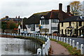
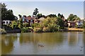
High Street, Lindfield
A view of the southern end from the common with the Town Pond on the left.
Image: © Simon Carey
Taken: 30 Aug 2015
0.01 miles
3
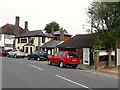
The White Horse public house, Lindfield
Image: © Stacey Harris
Taken: 30 Mar 2011
0.01 miles
4
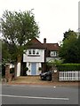
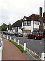
14-16, High Street, Lindfield
A pair if cottages that date from at least the mid 19th century as they appear on Lindfield's 1845 tithe map and predate Image their neighbours to the south. Number 14 is the dwelling whilst 16 has had a shop front built as an extension and is currently home to Lindfield Barbers.
Image: © Simon Carey
Taken: 30 Aug 2015
0.01 miles
5
High Street, Lindfield, Sussex
Looking towards King Edward Hall, and the White Horse public house. The traditional pub sign had just been removed (seen on the extreme right of picture), and a new 'trendy' sign was in place by the afternoon.
Image: © Peter Trimming
Taken: 4 Nov 2011
0.02 miles
6
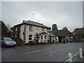
White Horse, High Street, Lindfield
One of four pubs on the High Street though this one appears to be closed at the moment with the local parish council recently (June 2015) making an application to turn it into an Asset of Community Value after hearing rumours of a possible conversion into a convenience store. The pub dates from the 19th century and overlooks the pond. The building to the right is number 20 and was for 15 years home to a florist until they moved in January 2015 after problems renewing the lease. To the left is Image
Image: © Simon Carey
Taken: 30 Aug 2015
0.02 miles
7
King Edward Hall, High Street, Lindfield
The village hall was opened in 1911 on the site of the gardens and former stables belonging to Image It has been extended a number of times the last in 1977. The building includes a Social Club, something stipulated in the original deeds, which is accessed to the rear, and once included a local library which closed in 1982. The current facilities include three bookable rooms of varying sizes.
Image: © Simon Carey
Taken: 30 Aug 2015
0.02 miles
8
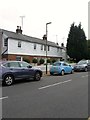
10-12, High Street, Lindfield
Now a pair of cottages called Pond cottage on the left and Pond View to the right. Built in the 19th century observing old maps as well as the visible brick work it appears this was once a small terrace of four cottages.
Image: © Simon Carey
Taken: 30 Aug 2015
0.02 miles
10
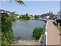
The village pond in Lindfield
Lindfield (the name means 'open land with lime trees') gained national notoriety when it had to withdraw from the Best Kept Village in all Sussex competition in order to give other villages a chance!
http://myweb.tiscali.co.uk/kenanderson/lindfieldvillage/
Image: © Russel Wills
Taken: 6 Jun 2013
0.02 miles