IMAGES TAKEN NEAR TO
High Street, HAYWARDS HEATH, RH16 2HG
Introduction
This page details the photographs taken nearby to High Street, RH16 2HG by members of the Geograph project.
The Geograph project started in 2005 with the aim of publishing, organising and preserving representative images for every square kilometre of Great Britain, Ireland and the Isle of Man.

There are currently over 7.5m images from over14,400 individuals and you can help contribute to the project by visiting https://www.geograph.org.uk
Image Map
Images are licensed for reuse under creativecommons.org/licenses/by-sa/2.0
Notes
- Clicking on the map will re-center to the selected point.
- The higher the marker number, the further away the image location is from the centre of the postcode.
Image Listing (143 Images Found)
Images are licensed for reuse under creativecommons.org/licenses/by-sa/2.0
Image
Details
Distance
1
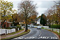
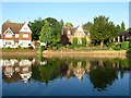
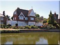
High Street, Lindfield, Sussex
Looking in the direction of the village centre, which lies around the bend, and beyond the pond.
Image: © Peter Trimming
Taken: 4 Nov 2011
0.01 miles
2
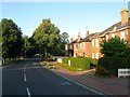
5-15, High Street, Lindfield
Late Victorian semi-detached town houses located just south of the pond. To the right is the northern end of the common.
Image: © Simon Carey
Taken: 9 Aug 2015
0.01 miles
3
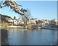
Lindfield Pond on a cold Xmas eve
The classic pond at the bottom of the village high street attracts ducks and children !
Image: © Nigel Freeman
Taken: 24 Dec 2001
0.02 miles
4
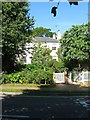
1-3, High Street, Lindfield
A pair of mid Victorian semi-detached cottages overlooking the northern end of the common. Unfortunately part concealed with foliage.
Image: © Simon Carey
Taken: 6 Sep 2015
0.02 miles
5
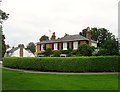
The Pondcroft/Eldon Lodge, Pondcroft Road, Lindfield
The Pondcroft is the house on the left with Eldon Lodge to the right. Pondcroft Road is a small private cul de sac off High Street that skirts the southern side of the pond and was developed with substantial villas in the 1880s.
Image: © Simon Carey
Taken: 9 Aug 2015
0.02 miles
6
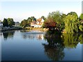
Lindfield Pond
The pond is very old and lies at the southern end of the High Street and northern tip of the common though 19th century development has now severed the link though the latter can be seen in the distance.
Image: © Simon Carey
Taken: 9 Aug 2015
0.03 miles
7
8, High Street, Lindfield
Known as Bay Pond Cottage and built in the 1690s as an encroachment on the common. To the left are Image
Image: © Simon Carey
Taken: 30 Aug 2015
0.03 miles
8
6, High Street, Lindfield
Originally called Pelham Villa but now known as Pelham House it was built in 1830 next to Lindfield Common and is the first house on the eastern side coming from the south. Beyond is Image
Image: © Simon Carey
Taken: 30 Aug 2015
0.03 miles
10
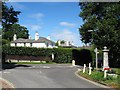
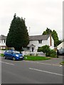
St Anne's, Black Hill, Lindfield
Viewed from the junction with Backwoods Lane the house was built around 1830 and looks out over the common. To the right is a drinking trough and water fountain erected in 1911 as a coronation memorial.
Image: © Simon Carey
Taken: 9 Aug 2015
0.03 miles