IMAGES TAKEN NEAR TO
Hanlye Lane, HAYWARDS HEATH, RH16 1XN
Introduction
This page details the photographs taken nearby to Hanlye Lane, RH16 1XN by members of the Geograph project.
The Geograph project started in 2005 with the aim of publishing, organising and preserving representative images for every square kilometre of Great Britain, Ireland and the Isle of Man.

There are currently over 7.5m images from over14,400 individuals and you can help contribute to the project by visiting https://www.geograph.org.uk
Image Map
Images are licensed for reuse under creativecommons.org/licenses/by-sa/2.0
Notes
- Clicking on the map will re-center to the selected point.
- The higher the marker number, the further away the image location is from the centre of the postcode.
Image Listing (22 Images Found)
Images are licensed for reuse under creativecommons.org/licenses/by-sa/2.0
Image
Details
Distance
1
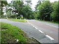
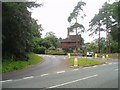
Hanlye Lane branching left off Balcombe Road
Travelling north from the junction, Balcombe Road becomes Bordehill Lane. The stone gateway to the left is South Lodge part of the Borde Hill Estate.
Image: © Dave Spicer
Taken: 10 Jul 2011
0.01 miles
2
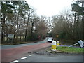
Balcombe Road, junction with Hanlye Lane, Haywards Heath
Image: © Stacey Harris
Taken: 23 Jan 2010
0.02 miles
3
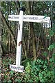
Old Direction Sign - Signpost by Balcombe Road, Ansty and Staplefield Parish
Black iron cap finial - 3 arms; East Sussex wood by the UC road, in parish of Ansty and Staplefield (Mid Sussex District), opposite junction of Hanlye Lane, with Borde Hill Lane and Balcombe Road (parish now Ansty and Staplefield), on verge opposite junction.
Surveyed
Milestone Society National ID: SX_TQ3225
Image: © Milestone Society
Taken: Unknown
0.03 miles
4
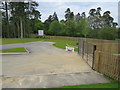
Roundabout between Borde Hill Lane / Hanley Lane / Balcombe Road during construction
This is the roundabout between Borde Hill Lane, Hanley Lane and Balcombe Road before it was completed.
Image: © Thoma
Taken: 5 May 2019
0.03 miles
5
The turning for Hanlye Lane and Cuckfield
On the corner of the Borde Hill estate
Image: © Nigel Freeman
Taken: 6 Jul 2005
0.04 miles
6
Horse jumps at the Borde Hill Horse Trials
Image: © Dave Spicer
Taken: 10 Jul 2011
0.07 miles
7
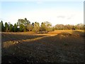
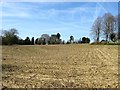
Kiln Field (2)
The north eastern part of Image which will soon be lost to the development of Penland Farm housing estate. Part of the field was lost in the 1960s with the construction of Penland Road and The Spinney. See also Image
Image: © Simon Carey
Taken: 12 Apr 2015
0.10 miles
8
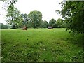
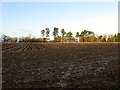
Five Acres/Kiln Field
The name of the fields according to Cuckfield's 1843 tithe map. Five Acres is in the foreground covered in shadows and has now been extended to include Image to the south. Kiln Field lies beyond the hedge and is bounded by Hanlye lane to the north and Balcombe Road to the east. The south west corner of the field was developed in the early 1960s and now contains Image The titular kiln was still marked on the 1875 OS map and was located roughly where the junction of Penland Road and Balcombe road stands.
Image: © Simon Carey
Taken: 24 Jan 2015
0.11 miles
9
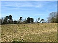
Kiln Field (1)
The name of the field according to Cuckfield's 1843 tithe map that is located to the east of Image The field has lost its eastern part to the development of Penland Road and The Spinney and is due to disappear entirely in the next few years as the Penland Farm housing estate will be built here. See also Image and Image
Image: © Simon Carey
Taken: 12 Apr 2015
0.16 miles
10
Upper Four Acres/Lower Four Acres
The name of the fields according to Cuckfield's 1843 tithe map that have been merged to form a larger unit. Upper Four Acres lay adjacent to Hanlye Lane to the north whilst Lower four Acres was to the south next to Penlands Farm and Image
Image: © Simon Carey
Taken: 24 Jan 2015
0.16 miles