IMAGES TAKEN NEAR TO
Lucastes Lane, HAYWARDS HEATH, RH16 1LE
Introduction
This page details the photographs taken nearby to Lucastes Lane, RH16 1LE by members of the Geograph project.
The Geograph project started in 2005 with the aim of publishing, organising and preserving representative images for every square kilometre of Great Britain, Ireland and the Isle of Man.

There are currently over 7.5m images from over14,400 individuals and you can help contribute to the project by visiting https://www.geograph.org.uk
Image Map
Images are licensed for reuse under creativecommons.org/licenses/by-sa/2.0
Notes
- Clicking on the map will re-center to the selected point.
- The higher the marker number, the further away the image location is from the centre of the postcode.
Image Listing (27 Images Found)
Images are licensed for reuse under creativecommons.org/licenses/by-sa/2.0
Image
Details
Distance
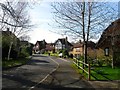
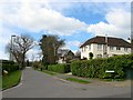
1
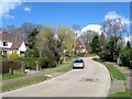
Lucastes Lane, Haywards Heath
The western end of Lucastes Lane along with neighbouring lincoln Wood was developed in the late 1950s with this section once a field called Ashurst Mead according to Cuckfield's 1843 tithe map.
Image: © Simon Carey
Taken: 31 Mar 2015
0.03 miles
2
Lincoln Wood, Haywards Heath
A residential road that runs south from Lucastes lane then turns west to meet up again with the same road. The estate was built in the late 1950s on a former wood that had been a field called The Wrenery at the time of Cuckfield's 1843 tithe map.
Image: © Simon Carey
Taken: 12 Apr 2015
0.08 miles
3
Hillside Walk, Haywards Heath
A cul de sac off Blunts Wood Road that was built in the early 1970s on the eastern part of Blunts Wood.
Image: © Simon Carey
Taken: 31 Mar 2015
0.08 miles
4
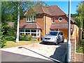
New house, Lincoln Wood, Haywards Heath
Image: © Alex McGregor
Taken: 8 Jun 2011
0.08 miles
5
The Droveway, Haywards Heath
A cul de sac off Lucastes Lane which was built in the grounds of a house called The Droveway sometime during the 1980s. The house itself occupies a former field called Pit Field according to Cuckfield's 1843 tithe map with the titular pit becoming a large pond which can still be found in the grounds of the house on the right.
Image: © Simon Carey
Taken: 12 Apr 2015
0.10 miles
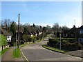
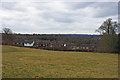
6
View towards Blunts Wood Road, Haywards Heath
The road takes its name from the wood behind it and to the left.
Image: © Robin Webster
Taken: 14 Mar 2010
0.12 miles
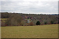
7
View over the west fringe of Haywards Heath
Viewed from Parkland, one of the meadows of Blunts Wood and Paiges Meadows nature reserve, which forms a gap between Haywards Heath and Cuckfield.
Image: © Robin Webster
Taken: 14 Mar 2010
0.13 miles
8
Foxwarren, Haywards Heath
A cul de sac off Sherwood Drive that was developed in the mid 1970s on the site of a former field called The Wrenery, according to Cuckfield's 1843 tithe map.
Image: © Simon Carey
Taken: 31 Mar 2015
0.13 miles
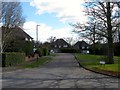
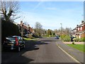
9
Lucastes Lane, Haywards Heath
Laid out by the time of the 1910 OS map though no houses had been built and development was sparse during the interwar years and did not take off until the 1950s. Viewed from the junction with Lucastes Avenue.
Image: © Simon Carey
Taken: 30 Mar 2015
0.14 miles
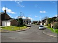
10
Sherwood Drive, Haywards Heath
A cul de sac built in the mid 1970s off Lincoln Wood in the southern part of a former wood that had been a field called The Wrenery on Cuckfield's 1843 tithe map.
Image: © Simon Carey
Taken: 12 Apr 2015
0.15 miles