IMAGES TAKEN NEAR TO
Lucas Way, HAYWARDS HEATH, RH16 1JR
Introduction
This page details the photographs taken nearby to Lucas Way, RH16 1JR by members of the Geograph project.
The Geograph project started in 2005 with the aim of publishing, organising and preserving representative images for every square kilometre of Great Britain, Ireland and the Isle of Man.

There are currently over 7.5m images from over14,400 individuals and you can help contribute to the project by visiting https://www.geograph.org.uk
Image Map
Images are licensed for reuse under creativecommons.org/licenses/by-sa/2.0
Notes
- Clicking on the map will re-center to the selected point.
- The higher the marker number, the further away the image location is from the centre of the postcode.
Image Listing (77 Images Found)
Images are licensed for reuse under creativecommons.org/licenses/by-sa/2.0
Image
Details
Distance
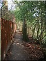
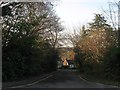
1
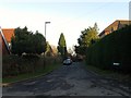
Lucas Way, Haywards Heath
Small cul de sac off Image developed in the late 1950s.
Image: © Simon Carey
Taken: 8 Feb 2015
0.02 miles
2
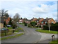
Sergison Close, Haywards Heath
A cul de sac that heads south from Sergison Road and is connected to Butlers Green Road by a small path. Originally a field called Pit Field according to Cuckfield's 1843 tithe map it later became part of Paddockhall Gardens and nursery until this section was developed during the mid 1960s. The close was extended further south in the 1980s. The junction on the right is with Image
Image: © Simon Carey
Taken: 30 Mar 2015
0.05 miles
3
Nursery Close, Haywards Heath
A small cul de sac off Sergison Close that was built in the 1960s on the site of Paddockhall Gardens and nursery.
Image: © Simon Carey
Taken: 30 Mar 2015
0.09 miles
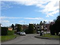
4
Sergison Road, Haywards Heath
A residential road that runs between Paddockhall Road and Lucastes Road that was developed in the 1960s. This section was once a field called Bridge Field according to Cuckfield's 1843 tithe map and after the Second World War became part of a nursery called Paddockhall Gardens. The road junction visible in the distance is with Nursery Close. See also Image
Image: © Simon Carey
Taken: 8 Feb 2015
0.10 miles
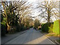
5
Footpath to Lucastes Road, Haywards Heath
Currently linking Sherwood Drive to Lucastes Road. To the south is a new development being built called Lucastes.
Image: © Simon Carey
Taken: 12 Apr 2015
0.11 miles
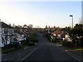
6
Lucastes Road, Haywards Heath
The current road runs southward from Lucastes Avenue and was laid out in the first decade of the 20th century.
Image: © Simon Carey
Taken: 8 Feb 2015
0.11 miles
7
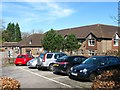
Beech Hurst, Butlers Green Road, Haywards Heath
A purpose built care home built in the grounds of the former Haywards Heath Hospital.
Image: © Simon Carey
Taken: 12 Apr 2015
0.11 miles
8
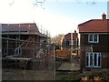
New Development, Haywards Heath
Currently being built on the western edge of the town in a former field called Wig Perry Mead according to Cuckfield's 1843 tithe map. The field name itself lives on in Image whilst the new development is accessed at the southern end of Image
Image: © Simon Carey
Taken: 8 Feb 2015
0.11 miles
9
Chillis Wood Road, Haywards Heath
A cul de sac off Image which was developed in the 1960s.
Image: © Simon Carey
Taken: 8 Feb 2015
0.12 miles
10
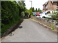
Path off Paddockhall Road
See also http://www.geograph.org.uk/photo/899909 from 2008.
Image: © Shazz
Taken: 20 May 2016
0.12 miles