IMAGES TAKEN NEAR TO
Sergison Road, HAYWARDS HEATH, RH16 1HS
Introduction
This page details the photographs taken nearby to Sergison Road, RH16 1HS by members of the Geograph project.
The Geograph project started in 2005 with the aim of publishing, organising and preserving representative images for every square kilometre of Great Britain, Ireland and the Isle of Man.

There are currently over 7.5m images from over14,400 individuals and you can help contribute to the project by visiting https://www.geograph.org.uk
Image Map
Images are licensed for reuse under creativecommons.org/licenses/by-sa/2.0
Notes
- Clicking on the map will re-center to the selected point.
- The higher the marker number, the further away the image location is from the centre of the postcode.
Image Listing (80 Images Found)
Images are licensed for reuse under creativecommons.org/licenses/by-sa/2.0
Image
Details
Distance
1
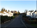
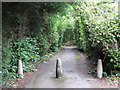
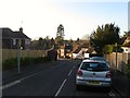
Sergison Road, Haywards Heath
A residential road that runs between Paddockhall Road and Lucastes Avenue that was developed during the 1960s. This view looks towards the junction with Paddockhall Road with the large Image on the left. See Image for a view from the top of that slope.
Image: © Simon Carey
Taken: 8 Feb 2015
0.04 miles
2
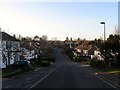
Sergison Road, Haywards Heath
A residential road that runs between Paddockhall Road and Lucastes Road that was developed in the 1960s. This section was once a field called Bridge Field according to Cuckfield's 1843 tithe map and after the Second World War became part of a nursery called Paddockhall Gardens. The road junction visible in the distance is with Nursery Close. See also Image
Image: © Simon Carey
Taken: 8 Feb 2015
0.04 miles
3
Nursery Close, Haywards Heath
A small cul de sac off Sergison Close that was built in the 1960s on the site of Paddockhall Gardens and nursery.
Image: © Simon Carey
Taken: 30 Mar 2015
0.05 miles
4
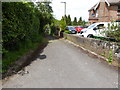
Path off Paddockhall Road
See also http://www.geograph.org.uk/photo/899909 from 2008.
Image: © Shazz
Taken: 20 May 2016
0.05 miles
6
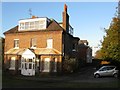
The Oaks, Paddockhall Road, Haywards Heath
Built during the late Victorian period this former townhouse has now been converted into five flats. Since the summer of 2014 permission has been granted to demolish this building and replace with a block containing 14 flats.
Image: © Simon Carey
Taken: 8 Feb 2015
0.05 miles
7
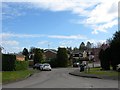
Sergison Close, Haywards Heath
A cul de sac that heads south from Sergison Road and is connected to Butlers Green Road by a small path. Originally a field called Pit Field according to Cuckfield's 1843 tithe map it later became part of Paddockhall Gardens and nursery until this section was developed during the mid 1960s. The close was extended further south in the 1980s. The junction on the right is with Image
Image: © Simon Carey
Taken: 30 Mar 2015
0.07 miles
8
Citizens Advice Bureau, Oaklands, Paddockhall Road, Haywards Heath
Located in a former clinic at the southern end of the complex containing Mid Sussex District Council.
Image: © Simon Carey
Taken: 8 Feb 2015
0.07 miles
9
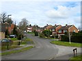
Wychperry Road, Haywards Heath
Currently a cul de sac off Paddockhall Road that was developed in the 1960s though the road itself is much older having originally been marked out on the 1874 OS map where it is shaped like a crescent and has a southern junction with Butlers green Road adjacent to Image and now occupied by a house called Wychperry Bower that was built between the wars. By the 1897 edition the road had been reduced to its current length though no building took place along it until the 1960s.
Image: © Simon Carey
Taken: 8 Feb 2015
0.08 miles
10
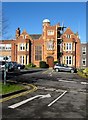
Oaklands, Oaklands Road, Haywards Heath
Currently home to Mid Sussex District Council though there are talks about moving to another site in Perrymount Road. Built in the 1860s as a large villa it was acquired in 1933 along with the grounds to become the administrative headquarters of Cuckfield Urban District Council which was instituted in 1934 and covered much of modern Haywards Heath. The building was extended in the 1960s with extensions either side and after the local government reorganisation in 1974 became the administrative centre for the newly constituted district of Mid Sussex.
Image: © Simon Carey
Taken: 17 Feb 2015
0.09 miles