IMAGES TAKEN NEAR TO
Alder Way, HAYWARDS HEATH, RH16 1AN
Introduction
This page details the photographs taken nearby to Alder Way, RH16 1AN by members of the Geograph project.
The Geograph project started in 2005 with the aim of publishing, organising and preserving representative images for every square kilometre of Great Britain, Ireland and the Isle of Man.

There are currently over 7.5m images from over14,400 individuals and you can help contribute to the project by visiting https://www.geograph.org.uk
Image Map
Images are licensed for reuse under creativecommons.org/licenses/by-sa/2.0
Notes
- Clicking on the map will re-center to the selected point.
- The higher the marker number, the further away the image location is from the centre of the postcode.
Image Listing (17 Images Found)
Images are licensed for reuse under creativecommons.org/licenses/by-sa/2.0
Image
Details
Distance
1
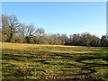
Two Acre Field
The name of the field according to Lindfield's 1845 tithe map that is bounded by the footpath to the west, Birchen Wood to the north west, the end of Brook Lane to the east and Image to the south.
Image: © Simon Carey
Taken: 17 Feb 2015
0.02 miles
3
Little North Mead
The name of the field according to Lindfield's 1845 tithe map that is bounded by Image to the north, the houses of Gatesmead to the east, Image to the south and the footpath to the west.
Image: © Simon Carey
Taken: 17 Feb 2015
0.07 miles
4
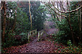
Footbridge on tree lined path to Wickham Farm
Image: © Dave Spicer
Taken: 10 Jul 2011
0.08 miles
5
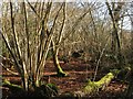
Birchen Wood
Marked as such on Lindfield's 1845 tithe map and still its current name.
Image: © Simon Carey
Taken: 17 Feb 2015
0.09 miles
6
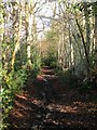
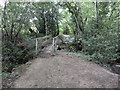
Footpath to Copyhold Lane
The path runs through a holloway on the western side of Birchen Wood and is difficult to negotiate during the winter with the locals diverting into the wood judging by the number of paths running through it.
Image: © Simon Carey
Taken: 17 Feb 2015
0.10 miles
7
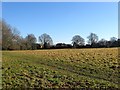
Field Number 70
The number of the field according to Lindfield's 1845 tithe map that was marked as a copse on that map but was open field by the time of the 1875 OS map. It is bounded by Image to the north, the houses of Birchen Lane to the east, the grounds of Sunte House to the south and the footpath to the west.
Image: © Simon Carey
Taken: 17 Feb 2015
0.13 miles
8
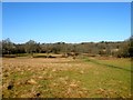
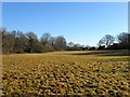
North Meadow/Eleven Acres/Spring Plot/Sign Hand
The name of the fields according to Lindfield's 1845 tithe map. North Meadow is in the foreground whilst the oaks mark the former hedgerows separating Eleven Acres to the left with Spring plot to the right. Beyond both of them is Sign Hand which once was a neighbour to Sign Hams Copse which was lost to development of the railway and later Orchard Close. Judging by the paths through the field it is well used b the locals in order to avoid the muddy morass of the public footpath.
Image: © Simon Carey
Taken: 17 Feb 2015
0.15 miles
9
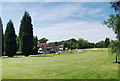
Haywards Heath Golf Course
A private members club founded in 1922 and having a very active membership. 18 holes 6216 yards. S.S.S. 70 . www.haywardsheathgolfclub.co.uk
Image: © Nigel Freeman
Taken: 21 Jun 2005
0.16 miles
10
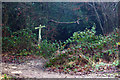
Footpath and signpost at the edge of golf course
This is where the path comes out of the wood and goes across Haywards Heath golf course.
Image: © Robert Eva
Taken: 30 Dec 2016
0.16 miles