IMAGES TAKEN NEAR TO
Bower Hill Close, REDHILL, RH1 5NQ
Introduction
This page details the photographs taken nearby to Bower Hill Close, RH1 5NQ by members of the Geograph project.
The Geograph project started in 2005 with the aim of publishing, organising and preserving representative images for every square kilometre of Great Britain, Ireland and the Isle of Man.

There are currently over 7.5m images from over14,400 individuals and you can help contribute to the project by visiting https://www.geograph.org.uk
Image Map
Images are licensed for reuse under creativecommons.org/licenses/by-sa/2.0
Notes
- Clicking on the map will re-center to the selected point.
- The higher the marker number, the further away the image location is from the centre of the postcode.
Image Listing (96 Images Found)
Images are licensed for reuse under creativecommons.org/licenses/by-sa/2.0
Image
Details
Distance
1
Victoria Cottages
A pair of semi-detached cottages in Kings Mead, off Kings Cross Lane
Image: © Ian Capper
Taken: 6 Mar 2010
0.06 miles
2
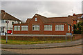
Camomile House
Premises of a chemical and food ingredient importer and distributor.
Image: © Ian Capper
Taken: 6 Mar 2010
0.08 miles
3
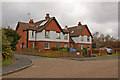
Netherleigh Lodge
On Kings Cross Lane. A nearby house on The Avenue is called Netherleigh (see Image) and building part of which can be seen on the extreme left of the photo is part of a development called Netherleigh Park.
Image: © Ian Capper
Taken: 6 Mar 2010
0.09 miles
4
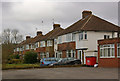
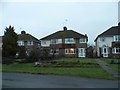
Semis in Kings Cross Lane
A row of inter war semi-detached houses on the edge of South Nutfield.
Image: © Ian Capper
Taken: 6 Mar 2010
0.09 miles
5
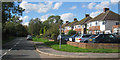
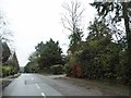
Houses on Kings Cross Lane, South Nutfield
Image: © David Howard
Taken: 24 Jan 2016
0.10 miles
7
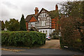
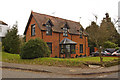
Netherleigh
Now split into two (with the right hand section called Shrublands), Netherleigh was one of a number of large late Victorian houses built in The Avenue following the opening of Nutfield Station in 1884.
Image: © Ian Capper
Taken: 6 Mar 2010
0.12 miles
8
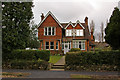
Kilronan
One of a number of late Victorian houses built in The Avenue following the opening of Nutfield Station in 1884. Compare the similar Woodcote (see Image).
Image: © Ian Capper
Taken: 6 Mar 2010
0.12 miles
10
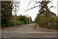
The Avenue
A road running from Kings Cross Lane (in the foreground in this photo) towards Nutfield Station. Although there has been some more modern infilling, most houses were built in the late 1900s, following the opening of Nutfield station in 1884. Two of the larger houses can be seen in this photo: Netherleigh on the left (see Image) and Avenue House on the right (see Image).
Image: © Ian Capper
Taken: 6 Mar 2010
0.13 miles