IMAGES TAKEN NEAR TO
Henry Burt Way, BURGESS HILL, RH15 9UX
Introduction
This page details the photographs taken nearby to Henry Burt Way, RH15 9UX by members of the Geograph project.
The Geograph project started in 2005 with the aim of publishing, organising and preserving representative images for every square kilometre of Great Britain, Ireland and the Isle of Man.

There are currently over 7.5m images from over14,400 individuals and you can help contribute to the project by visiting https://www.geograph.org.uk
Image Map
Images are licensed for reuse under creativecommons.org/licenses/by-sa/2.0
Notes
- Clicking on the map will re-center to the selected point.
- The higher the marker number, the further away the image location is from the centre of the postcode.
Image Listing (13 Images Found)
Images are licensed for reuse under creativecommons.org/licenses/by-sa/2.0
Image
Details
Distance
1
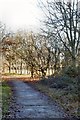
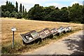
Winter Sun
Part of the Burgess Hill Green Circular Route, west of the A273.
Image: © Peter Jeffery
Taken: 22 Dec 2016
0.17 miles
3
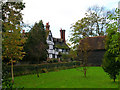
Hammonds Place, Burgess Hill
Hammonds Place was built in the 16th century. The original building was damaged by fire and it was subsequently rebuilt & added to. It was never a working farm though. Hammonds Farm was originally owned by Little Hammonds Farm House, which is situated opposite Hammonds Place tucked in just behind the barn you can see on the right. Little Hammonds Farm House (now known as Little Hammonds) dates back to the 1590's (extended in the early 1900's). The working farm was sold to developers Wates in the mid 1960's and subsequently developed in the late 1980's / early 1990's (Hammonds Ridge housing estate, Tesco, etc). In between outbuildings were used by Hammonds Place amongst others. Stabling and a large milking yard originally adjoined the house on the North Westerly corner. The barn in the picture was originally also part of the farm, it was developed into a residential dwelling in the late 1990's.
Information kindly provided by Craig Maddock.
Image: © Simon Carey
Taken: 5 Nov 2005
0.20 miles
4
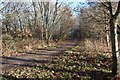
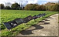
A Bridle Path
Part of the Burgess Hill Green Circular Route.
Image: © Peter Jeffery
Taken: 22 Dec 2016
0.20 miles
5
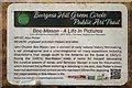
Bee-Mason, A Life in Pictures
Artwork placed alongside Burgess Hill's Green Circle. The Green Circle being a bridle path through the Green Belt that surrounds the town.
Image: © Peter Jeffery
Taken: 11 Jul 2018
0.21 miles
6
Information Plaque
Situated by the artwork depicting the life and work of John C Bee-Mason.
I have been given to understand that Mr. Mason added the "Bee" to his name by deed poll.
Image: © Peter Jeffery
Taken: 11 Jul 2018
0.21 miles
7
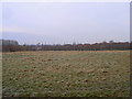
Hammonds Ridge Meadow
Part of the Green Crescent an area of green open access that connects Bedelands Farm nature reserve in the north then swings westwards around the boundary of Burgess Hill before ending at Batchelors Farm reserve in the south. The streetlights mark Jane Murray Way, the A273, whilst the building to the left is a Tesco superstore. The Priory estate, also known as the Tesco estate, is to the right.
Image: © Simon Carey
Taken: 4 Jan 2009
0.21 miles
8
Public Art Trail
Part of the Public Art Trail alongside the Green Circle Network near Burgess Hill. For a closer look see Image
Image: © Chris Thomas-Atkin
Taken: 5 Nov 2017
0.21 miles
9
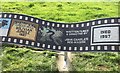
Artwork on The Green Circle
One of the three parts of the ‘A Life in Pictures’ artwork on the Green Circle Public Art Trail in Burgess Hill.
The artwork commemorates the life of John Charles Bee-Mason MBE, Filmmaker, Explorer and Naturalist who had lived in Burgess Hill. The artwork was created by the artist Alan Potter.
Image: © Chris Thomas-Atkin
Taken: 27 Sep 2017
0.21 miles
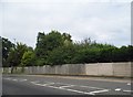
10
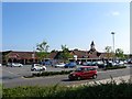
Tesco Superstore, Burgess Hill
Built in the 1990s and located to the south of the town next to the bypass.
Image: © Simon Carey
Taken: 7 Aug 2014
0.21 miles