IMAGES TAKEN NEAR TO
London Road, BURGESS HILL, RH15 9QH
Introduction
This page details the photographs taken nearby to London Road, RH15 9QH by members of the Geograph project.
The Geograph project started in 2005 with the aim of publishing, organising and preserving representative images for every square kilometre of Great Britain, Ireland and the Isle of Man.

There are currently over 7.5m images from over14,400 individuals and you can help contribute to the project by visiting https://www.geograph.org.uk
Image Map
Images are licensed for reuse under creativecommons.org/licenses/by-sa/2.0
Notes
- Clicking on the map will re-center to the selected point.
- The higher the marker number, the further away the image location is from the centre of the postcode.
Image Listing (14 Images Found)
Images are licensed for reuse under creativecommons.org/licenses/by-sa/2.0
Image
Details
Distance
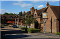
1
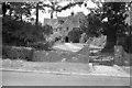
Hammonds Place
A Grade II listed building. The east front carries the date 1566.
Image: © Peter Jeffery
Taken: Unknown
0.06 miles
2
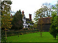
Hammonds Place, Burgess Hill
Hammonds Place was built in the 16th century. The original building was damaged by fire and it was subsequently rebuilt & added to. It was never a working farm though. Hammonds Farm was originally owned by Little Hammonds Farm House, which is situated opposite Hammonds Place tucked in just behind the barn you can see on the right. Little Hammonds Farm House (now known as Little Hammonds) dates back to the 1590's (extended in the early 1900's). The working farm was sold to developers Wates in the mid 1960's and subsequently developed in the late 1980's / early 1990's (Hammonds Ridge housing estate, Tesco, etc). In between outbuildings were used by Hammonds Place amongst others. Stabling and a large milking yard originally adjoined the house on the North Westerly corner. The barn in the picture was originally also part of the farm, it was developed into a residential dwelling in the late 1990's.
Information kindly provided by Craig Maddock.
Image: © Simon Carey
Taken: 5 Nov 2005
0.07 miles
3
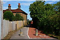
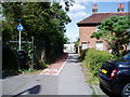
Cycle Lane, Burgess Hill, Sussex
A short cycle lane/path, linking Victoria Gardens and London Road.
Image: © Peter Trimming
Taken: 8 Aug 2011
0.18 miles
5
Public Footpath 23BH
With cycleway leading to Victoria Gardens and Albert Drive.
Image: © Peter Holmes
Taken: 18 Jul 2009
0.19 miles
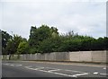
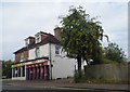
6
Gravett Court, Burgess Hill, Sussex
A relatively modern development, to the north of Station Road.
Image: © Peter Trimming
Taken: 8 Aug 2011
0.20 miles
8
Gateway Baptist Church, Station Road
There has been a Baptist presence in Burgess Hill since 1873. This Church was built between 1965 and 1966 to replace an earlier chapel elsewhere in the town.
Image: © Peter Holmes
Taken: 18 Jul 2009
0.22 miles
9
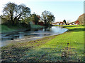
Flooded amenity land
A scrap of open space, only accessible from Potters Lane in the distance. Its propensity to flood may be the reason it has been left undeveloped. Frost persists in the shade, and the water is lightly iced over.
Image: © Robin Webster
Taken: 26 Nov 2010
0.22 miles
10
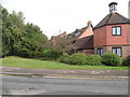
Flats on Queen Elizabeth Avenue, Burgess Hill
Image: © David Howard
Taken: 9 Aug 2018
0.24 miles