IMAGES TAKEN NEAR TO
The Saffrons, BURGESS HILL, RH15 8TB
Introduction
This page details the photographs taken nearby to The Saffrons, RH15 8TB by members of the Geograph project.
The Geograph project started in 2005 with the aim of publishing, organising and preserving representative images for every square kilometre of Great Britain, Ireland and the Isle of Man.

There are currently over 7.5m images from over14,400 individuals and you can help contribute to the project by visiting https://www.geograph.org.uk
Image Map (Loading...)


Getting Data...Please wait
Leaflet Map data © OpenStreetMap
Images are licensed for reuse under creativecommons.org/licenses/by-sa/2.0
Notes
- Clicking on the map will re-center to the selected point.
- The higher the marker number, the further away the image location is from the centre of the postcode.
Image Listing (15 Images Found)
Images are licensed for reuse under creativecommons.org/licenses/by-sa/2.0
Image
Details
Distance
1
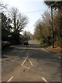
London Road, Burgess Hill
Currently the B2036 heading north from the junction with the A273 which until 1991 was the designation of this road. The highway itself is sometimes known as Fairplace Hill.
Image: © Simon Carey
Taken: 9 Apr 2015
0.13 miles
2
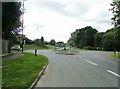
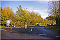
Roundabout at the junction of the A273 and B2036
Taken from the entrance to Sheddingdean Industrial Estate. The A273 on the far side of the roundabout turns left to Haywards Heath.
Image: © Dave Spicer
Taken: 14 Aug 2011
0.14 miles
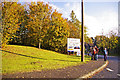
3
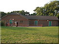
West End Meadows pavilion
West End Meadows Pavilion (The Brooks), Burgess Hill, owned by Mid Sussex District Council.
Image: © David Cumberland
Taken: 7 Jul 2008
0.14 miles
4
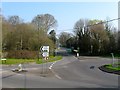
Fairplace Bridge, Burgess Hill
Marking the northern end of Burgess Hill where the A273 crosses over the River Adur. It was located between the two roundabouts, the one in the foreground containing the junction for the A273 and B2036 and the one beyond the bridge is where Isaac's Lane, the A273, heads north east to Haywards Heath and Cuckfield Road, the B2036, heads north west to Ansty and Cuckfield.
Image: © Simon Carey
Taken: 9 Apr 2015
0.14 miles
5
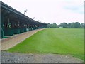
Burgess Hill Golf Centre
At this 9 hole course there is a floodlit 28 bay driving range.
Image: © Nigel Freeman
Taken: 2 Jul 2005
0.16 miles
6
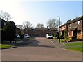
Marchants Way, Burgess Hill
Marchants Way as seen from the roundabout.
Image: © Christine Matthews
Taken: 2 Nov 2008
0.17 miles
7
Woodcroft, Burgess Hill
A small cul de sac off Marchants Way that occupies a former field called Bounty Field according to Clayton's 1838 tithe map which later became gardens for properties fronting onto London Road.
Image: © Simon Carey
Taken: 9 Apr 2015
0.17 miles
8
Bridge over River Adur, Burgess Hill
Bridge over River Adur as seen from the roundabout at the junction of the B2036 and A273.
Image: © Christine Matthews
Taken: 2 Nov 2008
0.18 miles
9
Marchants Way, Burgess Hill
Marchants Way is an access road to the Sheddington Business Centre and the Ashwyn Business Centre.
Image: © Christine Matthews
Taken: 2 Nov 2008
0.18 miles
10
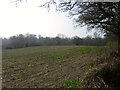
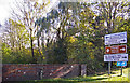
Banky Field
The name of the field according to Clayton's 1838 tithe map that is bounded by Isaac's Lane to the west, Fairbridge Way to the south and east, and Image to the north.
Image: © Simon Carey
Taken: 9 Apr 2015
0.20 miles