IMAGES TAKEN NEAR TO
New Fairplace Hill, BURGESS HILL, RH15 8GL
Introduction
This page details the photographs taken nearby to New Fairplace Hill, RH15 8GL by members of the Geograph project.
The Geograph project started in 2005 with the aim of publishing, organising and preserving representative images for every square kilometre of Great Britain, Ireland and the Isle of Man.

There are currently over 7.5m images from over14,400 individuals and you can help contribute to the project by visiting https://www.geograph.org.uk
Image Map
Images are licensed for reuse under creativecommons.org/licenses/by-sa/2.0
Notes
- Clicking on the map will re-center to the selected point.
- The higher the marker number, the further away the image location is from the centre of the postcode.
Image Listing (26 Images Found)
Images are licensed for reuse under creativecommons.org/licenses/by-sa/2.0
Image
Details
Distance
1

Ashwyn Business Centre, Marchants Way, Burgess Hill
On the Sheddingdean Industrial Estate and consisting of ten individual units.
Image: © Simon Carey
Taken: 9 Apr 2015
0.08 miles
2

The Penny Black, Marchants Way, Burgess Hill
On the Sheddingdean Industrial Estate and home to Accelerated Mail & Marketing.
Image: © Simon Carey
Taken: 9 Apr 2015
0.08 miles
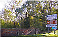
3
Bridge on Fairbridge Way
Fairbridge Way starts near where the main road crosses the same stream by Fairplace Bridge, so this is probably not Fair Bridge. The surroundings here are rather far from fair - they include an old sewage works, the town dump, and one of the less fair sorts of caravan park.
Image: © Robin Webster
Taken: 26 Mar 2010
0.10 miles
4

Marchants Way, Burgess Hill
Part of the Sheddingdean Industrial Estate that was opened in 1986.
Image: © Simon Carey
Taken: 9 Apr 2015
0.10 miles
5
Marchants Way, Burgess Hill
Marchants Way is an access road to the Sheddington Business Centre and the Ashwyn Business Centre.
Image: © Christine Matthews
Taken: 2 Nov 2008
0.11 miles
6
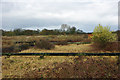
Old sewage works, Burgess Hill
In one of the less salubrious fringes of town, near the municipal dump.
Image: © Robin Webster
Taken: 26 Mar 2010
0.11 miles
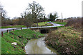
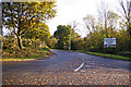
7
Bridge over River Adur, Burgess Hill
Bridge over River Adur as seen from the roundabout at the junction of the B2036 and A273.
Image: © Christine Matthews
Taken: 2 Nov 2008
0.12 miles
8
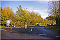
Marchants Way, Burgess Hill
Marchants Way as seen from the roundabout.
Image: © Christine Matthews
Taken: 2 Nov 2008
0.13 miles
9
Fairbridge Way, access road to Industrial Units, Burgess Hill
As seen from the A273 roundabout.
Image: © Christine Matthews
Taken: 2 Nov 2008
0.13 miles
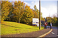
10
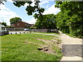
Footpath passes play area at end of Blackstone Way
Image: © Shazz
Taken: 24 May 2016
0.13 miles