IMAGES TAKEN NEAR TO
Phoenix Rise, BURGESS HILL, RH15 0UX
Introduction
This page details the photographs taken nearby to Phoenix Rise, RH15 0UX by members of the Geograph project.
The Geograph project started in 2005 with the aim of publishing, organising and preserving representative images for every square kilometre of Great Britain, Ireland and the Isle of Man.

There are currently over 7.5m images from over14,400 individuals and you can help contribute to the project by visiting https://www.geograph.org.uk
Image Map
Images are licensed for reuse under creativecommons.org/licenses/by-sa/2.0
Notes
- Clicking on the map will re-center to the selected point.
- The higher the marker number, the further away the image location is from the centre of the postcode.
Image Listing (29 Images Found)
Images are licensed for reuse under creativecommons.org/licenses/by-sa/2.0
Image
Details
Distance
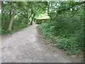
1
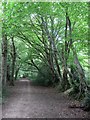
Bridleway to Ditchling Common
An old route judging by the embankments with trees marking field boundaries either side. The original bridleway left Keymer Road next to what is now the junction with Folders Lane but is now built over though its path can be traced. The eastern end is the only remaining part in its original state.
Image: © Simon Carey
Taken: 16 Aug 2009
0.05 miles
2
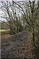
One O'clock Lane
The Eastern end, looking east.
Image: © Peter Jeffery
Taken: 1 Mar 2008
0.06 miles
3
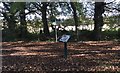
Path Junction and Information Board
One of the Information Boards created to explain about the Green Circle Network of paths around the Town of Burgess Hill.
Image: © Chris Thomas-Atkin
Taken: 5 Nov 2017
0.06 miles
4
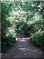
Bridleway to World's End
Linking this common to a suburb of Burgess Hill which lies to the south of another former common.
Image: © Simon Carey
Taken: 28 Aug 2009
0.07 miles
5
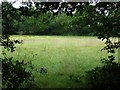
Little Fullers Field
The name of the field according to the 1843 tithe map and formerly part of Frankbarrow, a medieval deer park that was disparked in the 1530s.
Image: © Simon Carey
Taken: 16 Aug 2009
0.07 miles
6
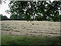
House Field
The name of the field according to the 1843 tithe map and formerly part of Frankbarrow, a medieval deer park that was disparked in the 1530s. Beyond the trees at the end of the field modern day Burgess Hill begins.
Image: © Simon Carey
Taken: 16 Aug 2009
0.08 miles
7
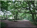
Bridleway Junction
The bridleway that links Ditchling Common near the crossroads to Manor Road in Burgess Hill meets another from the same time on the left. Both old routes that have been superseded by more modern highways.
Image: © Simon Carey
Taken: 16 Aug 2009
0.08 miles
8
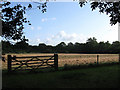
Great Park Meadow
The name of the field according to the 1843 tithe map. As the name suggests the field was once part of a medieval deer park called Frankbarrow which was disparked and enclosed in the 16th century. Much of it now lies under the concrete and tarmac of Burgess Hill.
Image: © Simon Carey
Taken: 28 Aug 2009
0.10 miles
9
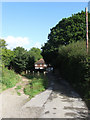
Hope Farm
Another farm located on the border of Ditchling Common. Farms would often supplement their small fields by using the common for much needed pasture. This farm would have originated some time in the 15th or 16th centuries when the land, a former deer park called Frankbarrow, to the west of the common was disparked and enclosed. The bridleway to World's End heads off to the left.
Image: © Simon Carey
Taken: 28 Aug 2009
0.11 miles
10
Property fence around the most easterly house in Burgess Hill
Image: © Dave Spicer
Taken: 15 May 2011
0.13 miles