IMAGES TAKEN NEAR TO
St. Georges Park, Ditchling Road, BURGESS HILL, RH15 0UT
Introduction
This page details the photographs taken nearby to St. Georges Park, Ditchling Road, RH15 0UT by members of the Geograph project.
The Geograph project started in 2005 with the aim of publishing, organising and preserving representative images for every square kilometre of Great Britain, Ireland and the Isle of Man.

There are currently over 7.5m images from over14,400 individuals and you can help contribute to the project by visiting https://www.geograph.org.uk
Image Map
Images are licensed for reuse under creativecommons.org/licenses/by-sa/2.0
Notes
- Clicking on the map will re-center to the selected point.
- The higher the marker number, the further away the image location is from the centre of the postcode.
Image Listing (32 Images Found)
Images are licensed for reuse under creativecommons.org/licenses/by-sa/2.0
Image
Details
Distance
1
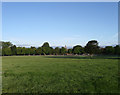
St George's Retreat
Viewed from Dry Pit Field, the name given to the field according to the 1843 tithe map. The retreat was opened in the mid 19th century as a catholic home for the mentally ill run by the Augustinian Nuns. They still run it but as a care home these days with a recent retirement village added on the northern side. The home also comes with 250 acres of farm and parkland.
Image: © Simon Carey
Taken: 16 Aug 2009
0.06 miles
2
St George's Retreat
The retreat was opened in the mid 19th century as a catholic home for the mentally ill run by the Augustinian Nuns. They still run it but as a care home these days with a recent retirement village added on the northern side. The home also comes with 250 acres of farm and parkland.
Image: © Simon Carey
Taken: 23 Aug 2009
0.06 miles
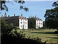
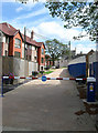
3
St George's Park
The buildings in the background are part of St George's retreat
Image: © Paul Gillett
Taken: 31 Jul 2014
0.07 miles
4
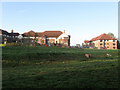
St George's Park Retirement Village
Built onto the northern end of St George's Retreat, originally a catholic home for the mentally ill that is now run as a successful care home. Oakview Court can be seen through the mist whilst the planned lake in the foreground has yet to be filled.
Image: © Simon Carey
Taken: 16 Aug 2009
0.09 miles
5
Northern Entrance, St George's Retreat
The original entrance to the former 19th Catholic home for the mentally ill now a combined care home and retirement village. The chapel can be seen in the distance.
Image: © Simon Carey
Taken: 16 Aug 2009
0.10 miles
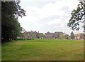
6
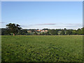
Dry Pit Field
The name of the field according to the 1843 tithe map though now near enough turned into parkland which belongs to nearby St George's Retreat. St Mary's House can be seen in the distance.
Image: © Simon Carey
Taken: 16 Aug 2009
0.11 miles
7
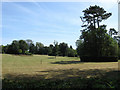
Gardens, St George's Retreat
Once a field called Nine Acres now landscaped gardens for St George's Retreat, originally a Catholic run home for the mentally ill but now run as a care home.
Image: © Simon Carey
Taken: 23 Aug 2009
0.12 miles
9
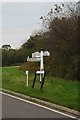
Old Direction Sign - Signpost by the B2112, Ditchling Road
Black iron cap finial - 3 arms; East Sussex wood with number by the B2112, Ditchling Road, in parish of Ditchling (Lewes District), junction of Janes Lane with the B2112, on verge opposite junction.
Surveyed
Milestone Society National ID: SX_TQ3319
Image: © Milestone Society
Taken: Unknown
0.15 miles
10
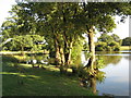
Relaxful Lake
Lovely relaxing lake at St George's Retreat.
Image: © Josie Campbell
Taken: 31 Aug 2013
0.15 miles