IMAGES TAKEN NEAR TO
The Camellias, BURGESS HILL, RH15 0UR
Introduction
This page details the photographs taken nearby to The Camellias, RH15 0UR by members of the Geograph project.
The Geograph project started in 2005 with the aim of publishing, organising and preserving representative images for every square kilometre of Great Britain, Ireland and the Isle of Man.

There are currently over 7.5m images from over14,400 individuals and you can help contribute to the project by visiting https://www.geograph.org.uk
Image Map
Images are licensed for reuse under creativecommons.org/licenses/by-sa/2.0
Notes
- Clicking on the map will re-center to the selected point.
- The higher the marker number, the further away the image location is from the centre of the postcode.
Image Listing (30 Images Found)
Images are licensed for reuse under creativecommons.org/licenses/by-sa/2.0
Image
Details
Distance
1
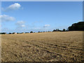
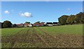
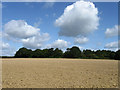
Nine Acres
The name of the field according to the 1843 tithe map and formerly part of Frankbarrow, a medieval deer park that was disparked and enclosed in the 16th century. The houses over the brow are in World's End, a suburb of Burgess Hill whilst to the north and south lie other built up areas which makes you wonder how long this field will survive before it follows others under the concrete and tarmac of Burgess Hill.
Image: © Simon Carey
Taken: 28 Aug 2009
0.05 miles
2
Entrance to Eight Acres
The name of the field according to the 1843 tithe map and formerly part of Frankbarrow, a medieval deer park that was disparked and enclosed in the 16th century. The parts of the field next to Janes Lane is now large houses and their gardens with the remaining rump now joined to the field called Nine Acres to the south. The track links the field to Janes Lane.
Image: © Simon Carey
Taken: 28 Aug 2009
0.08 miles
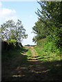
3
Janes Lane, World's End
At the very eastern edge of this suburb of Burgess Hill. The lane links the suburb with Ditchling Common and is an old enough route to form a former parish boundary between Ditchling and Cuckfield.
Image: © Simon Carey
Taken: 28 Aug 2009
0.09 miles
4
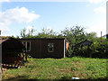
Awaiting Development, World's End
Small plot off Manor Road that has planning position for the construction of five houses. Looks like a former smallholding of some sort.
Image: © Simon Carey
Taken: 28 Aug 2009
0.12 miles
5
New Development on the Eastern edge of Burgess Hill
The view from a nearby public footpath of the new housing on the Eastern edge of the Town of Burgess Hill.
Image: © Chris Thomas-Atkin
Taken: 5 Nov 2017
0.14 miles
6
Three Corners
The name of the field according to the 1843 tithe map and formerly part of Frankbarrow, a medieval deer park that was disparked and enclosed in the 16th century. The name is also derived from the shape of the field bounded by the hedgerow on the left, Janes Lane to the top and the footpath to the east.
Image: © Simon Carey
Taken: 28 Aug 2009
0.15 miles
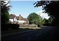
7
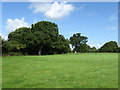
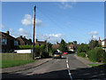
Manor Close, World's End
Small cul-de-sac off Manor Road in an area of Burgess Hill built up after the Second World War.
Image: © Simon Carey
Taken: 28 Aug 2009
0.15 miles
8
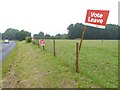
"Vote leave" times three on Janes Lane
The referendum is tomorrow.
Image: © Shazz
Taken: 22 Jun 2016
0.16 miles
9
The Brick Field
The name of the field according to the 1843 tithe map and formerly part of Frankbarrow, a medieval deer park that was disparked and enclosed in the 16th century. The name probably deriving from a previous use of digging for clay to produce bricks and tiles. There is still a working clay pit to the south.
Image: © Simon Carey
Taken: 28 Aug 2009
0.16 miles
10
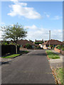
Eastdale Road, World's End
Small suburban road linking Manor Road with Northway. Much of the housing here was built after the Second World War.
Image: © Simon Carey
Taken: 28 Aug 2009
0.16 miles