IMAGES TAKEN NEAR TO
Ditchling Road, BURGESS HILL, RH15 0SF
Introduction
This page details the photographs taken nearby to Ditchling Road, RH15 0SF by members of the Geograph project.
The Geograph project started in 2005 with the aim of publishing, organising and preserving representative images for every square kilometre of Great Britain, Ireland and the Isle of Man.

There are currently over 7.5m images from over14,400 individuals and you can help contribute to the project by visiting https://www.geograph.org.uk
Image Map
Images are licensed for reuse under creativecommons.org/licenses/by-sa/2.0
Notes
- Clicking on the map will re-center to the selected point.
- The higher the marker number, the further away the image location is from the centre of the postcode.
Image Listing (15 Images Found)
Images are licensed for reuse under creativecommons.org/licenses/by-sa/2.0
Image
Details
Distance
1
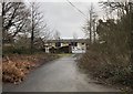
St Clare?s
St Claire’s is one of three care homes located at St George’s Park, Ditchling Common.
Image: © Chris Thomas-Atkin
Taken: 29 Dec 2019
0.02 miles
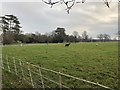
2
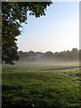
Kiln Field
The name of the field according to the 1843 tithe map. The field once belonged to Purchase Farm whose site is now occupied by St Mary's House whilst the land is owned by St George's Retreat, a former Catholic asylum now a retirement village. The latter's towers can just be seen through the early morning mist.
Image: © Simon Carey
Taken: 16 Aug 2009
0.05 miles
3
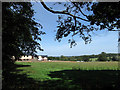
House Field
The name of the field according to the 1843 tithe map. The Rosary is the building on the left.
Image: © Simon Carey
Taken: 23 Aug 2009
0.08 miles
4
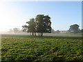
Nine Acres
The name of the field according to the 1843 tithe map. Once belonging to Purchase Farm now the site of St Mary's House which can be seen through the mist on higher ground it now belongs to St George's Retreat a former Catholic asylum that has now become a retirement village.
Image: © Simon Carey
Taken: 16 Aug 2009
0.12 miles
5
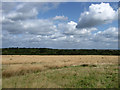
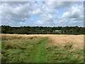
Ditchling Common Country Park
Looking down from the footpath next to the junction of the drive to Ditchling Common Stud and the B2112 where much of the land on the common is open grassland. The trees mark the western boundary of the common whilst the town of Haywards Heath is just visible in the distance on the right.
Image: © Simon Carey
Taken: 28 Aug 2009
0.14 miles
6
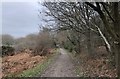
Ditchling Common
Heading northwards on a bridleway over the Ditchling Common Country Park.
Image: © Chris Thomas-Atkin
Taken: 29 Dec 2019
0.14 miles
8
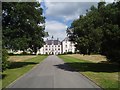
St George's Retreat
Initially it was set up as a retreat for the mentally ill, nowadays it is a care home successfully run by the Augustinian Care. And is soon to be very much expanded by the addition of many new homes for the over 60's. A sort of ideal retirement village set in 250 acres of Sussex farmland. www.stgeorgespark.co.uk/
Image: © Nigel Freeman
Taken: 12 Aug 2005
0.19 miles
9
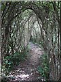
Willow Tunnel, Ditchling Common Country Park
Made with goat willow which is very supple and can be bent to grow in a particular direction. The path within leads from one of the trails towards an open air classroom next to a newly excavated small pond which is hoped will be used by the dragonflies which are prevalent on the common.
Image: © Simon Carey
Taken: 28 Aug 2009
0.19 miles
10
Footpath, Ditchling Common Country Park
Although there are a number of designated footpaths and bridleways running through the common there are also a lot more tracks that allow access. This designated footpath heads down towards Ditchling Common Stud from the B2112.
Image: © Simon Carey
Taken: 28 Aug 2009
0.20 miles