IMAGES TAKEN NEAR TO
Mostyn Terrace, REDHILL, RH1 4DJ
Introduction
This page details the photographs taken nearby to Mostyn Terrace, RH1 4DJ by members of the Geograph project.
The Geograph project started in 2005 with the aim of publishing, organising and preserving representative images for every square kilometre of Great Britain, Ireland and the Isle of Man.

There are currently over 7.5m images from over14,400 individuals and you can help contribute to the project by visiting https://www.geograph.org.uk
Image Map
Images are licensed for reuse under creativecommons.org/licenses/by-sa/2.0
Notes
- Clicking on the map will re-center to the selected point.
- The higher the marker number, the further away the image location is from the centre of the postcode.
Image Listing (40 Images Found)
Images are licensed for reuse under creativecommons.org/licenses/by-sa/2.0
Image
Details
Distance
1
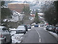
Philanthropic Road, Redhill
Looking downhill towards junction with Hooley Lane. The large gas holder is one of a pair on a gas holding station on Hooley Lane.
Image: © Rib
Taken: 11 Jan 2010
0.01 miles


6
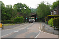
Railway bridge over Hooley Lane
The bridge is only wide enough for a single lane controlled by traffic lights. The railway runs from Redhill to Tonbridge.
Image: © Bill Boaden
Taken: 17 May 2019
0.10 miles


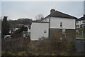
9
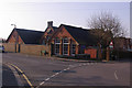
Earlswood Infant and Nursery School
A school for 3 - 7 year olds. The building dates from 1908.
Image: © Ian Capper
Taken: 21 Mar 2009
0.12 miles
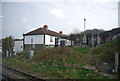
10
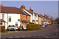
St John's Road
This part of Earlswood was developed at the very end of the 19th century - a plaque just visible on a house about half way along this row of houses gives a date of 1898.
Image: © Ian Capper
Taken: 21 Mar 2009
0.12 miles