IMAGES TAKEN NEAR TO
Honeybridge Lane, HORSHAM, RH13 8NX
Introduction
This page details the photographs taken nearby to Honeybridge Lane, RH13 8NX by members of the Geograph project.
The Geograph project started in 2005 with the aim of publishing, organising and preserving representative images for every square kilometre of Great Britain, Ireland and the Isle of Man.

There are currently over 7.5m images from over14,400 individuals and you can help contribute to the project by visiting https://www.geograph.org.uk
Image Map (Loading...)


Getting Data...Please wait
Leaflet Map data © OpenStreetMap
Images are licensed for reuse under creativecommons.org/licenses/by-sa/2.0
Notes
- Clicking on the map will re-center to the selected point.
- The higher the marker number, the further away the image location is from the centre of the postcode.
Image Listing (33 Images Found)
Images are licensed for reuse under creativecommons.org/licenses/by-sa/2.0
Image
Details
Distance
1
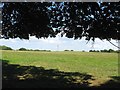
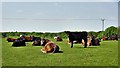
Common Field/Six Acres
The name of the fields according to West Grinstead's 1841 tithe map that have been combined to form a larger unit. Common Field was in the foreground adjacent to Windsor Common whilst Six Acres was located around the small peak in the distance.
Image: © Simon Carey
Taken: 30 Aug 2016
0.05 miles
2
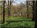
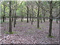
Windsor Common
Spring is approaching judging by the ground in the wood. Viewed from Honeybridge Lane.
Image: © Simon Carey
Taken: 28 Apr 2013
0.08 miles
4
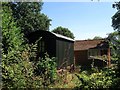
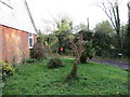
Shepherds Hut, Pot Hill House, Honeybridge Lane
A mobile shepherds hut in the grounds of the holiday let belonging to Pot Hill House. Viewed from the public footpath that links Honeybridge Lane to Sands Lane.
Image: © Simon Carey
Taken: 30 Aug 2016
0.08 miles
5
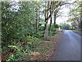
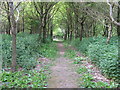
Public Footpath FP1859
Off Honeybridge Lane
Image: © The Saunterer
Taken: 2 Nov 2012
0.10 miles
6
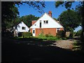
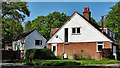
Pot Hill House, Honeybridge Lane
A lodge was built here in the first decade of the 20th century for Pothill Farm and appears to have been extended in the early 1960s. The structure to the left was a former ancillary building that was recently converted into a holiday let.
Image: © Simon Carey
Taken: 30 Aug 2016
0.10 miles
8
Approaching path junction in Grinder's Wood
Should have ticked supp. when submitting
Image: © Dave Spicer
Taken: 9 May 2009
0.10 miles