IMAGES TAKEN NEAR TO
Horsham Road, HORSHAM, RH13 8AH
Introduction
This page details the photographs taken nearby to Horsham Road, RH13 8AH by members of the Geograph project.
The Geograph project started in 2005 with the aim of publishing, organising and preserving representative images for every square kilometre of Great Britain, Ireland and the Isle of Man.

There are currently over 7.5m images from over14,400 individuals and you can help contribute to the project by visiting https://www.geograph.org.uk
Image Map
Images are licensed for reuse under creativecommons.org/licenses/by-sa/2.0
Notes
- Clicking on the map will re-center to the selected point.
- The higher the marker number, the further away the image location is from the centre of the postcode.
Image Listing (29 Images Found)
Images are licensed for reuse under creativecommons.org/licenses/by-sa/2.0
Image
Details
Distance
1
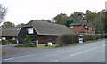
Brook Farm, West Sussex
Situated on the E side of the A281, quarter of a mile N of the centre of Cowfold. The barn and some other surrounding buildings are used as commercial premises.
Image: © Pete Chapman
Taken: 30 Nov 2005
0.05 miles
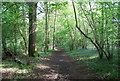
2
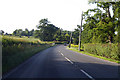
A281 towards Horsham
Leaving the outskirts of Cowfold.
Image: © Robin Webster
Taken: 27 Jun 2019
0.13 miles
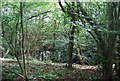
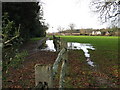
3
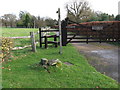
Footpath east from the A281
Also the driveway to Littlebrook
Image: © Dave Spicer
Taken: 28 Nov 2009
0.16 miles
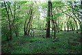
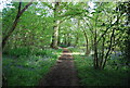
4
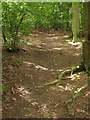
Baker's Shaw
Following the footpath to Cowfold as it travels through this small wood.
Image: © Simon Carey
Taken: 24 Aug 2010
0.18 miles
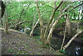
5
View west from Littlebrook driveway
The trees on the left are the northern perimeter of Brook Place
Image: © Dave Spicer
Taken: 28 Nov 2009
0.18 miles