IMAGES TAKEN NEAR TO
Highlands Road, HORSHAM, RH13 5LL
Introduction
This page details the photographs taken nearby to Highlands Road, RH13 5LL by members of the Geograph project.
The Geograph project started in 2005 with the aim of publishing, organising and preserving representative images for every square kilometre of Great Britain, Ireland and the Isle of Man.

There are currently over 7.5m images from over14,400 individuals and you can help contribute to the project by visiting https://www.geograph.org.uk
Image Map (Loading...)


Getting Data...Please wait
Leaflet Map data © OpenStreetMap
Images are licensed for reuse under creativecommons.org/licenses/by-sa/2.0
Notes
- Clicking on the map will re-center to the selected point.
- The higher the marker number, the further away the image location is from the centre of the postcode.
Image Listing (37 Images Found)
Images are licensed for reuse under creativecommons.org/licenses/by-sa/2.0
Image
Details
Distance
1
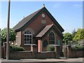
Hope Baptist chapel
On the corner of Oakhill Road and Clarence Road this Strict Baptist chapel opened in 1903 and retains its congregation today.
Image: © Andy Potter
Taken: 22 May 2007
0.11 miles
2
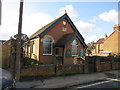
Hope Strict Baptist Chapel
Built in 1903
Image: © The Saunterer
Taken: 2 Feb 2013
0.11 miles
3
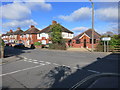
Road Junction
Clarence Road and Oakhill Road
Image: © The Saunterer
Taken: 2 Feb 2013
0.11 miles
7
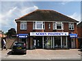
Nories Pharmacy
Bucking the trend of small, local shops closing and being converted into houses this pharmacist is thriving.
Image: © Andy Potter
Taken: 22 May 2007
0.16 miles
8
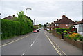
Horsham, Brighton road
Brighton road, Horsham. The A281 heading up a slight hill south-west to Brighton via Cowfold and Henfield.
Image: © Peter Cox
Taken: 4 Apr 2007
0.16 miles
9
St. Leonard's Community Infant and Nursery School
I think it was originally opened in 1915 as a girls' council.
Image: © Andy Potter
Taken: 17 Apr 2007
0.16 miles
10
The southern end of Stirling Way
See also http://www.geograph.org.uk/photo/1287849 from 2009.
Image: © Shazz
Taken: 29 Feb 2016
0.17 miles