IMAGES TAKEN NEAR TO
Mill Lane, HORSHAM, RH13 0NP
Introduction
This page details the photographs taken nearby to Mill Lane, RH13 0NP by members of the Geograph project.
The Geograph project started in 2005 with the aim of publishing, organising and preserving representative images for every square kilometre of Great Britain, Ireland and the Isle of Man.

There are currently over 7.5m images from over14,400 individuals and you can help contribute to the project by visiting https://www.geograph.org.uk
Image Map (Loading...)


Getting Data...Please wait
Leaflet Map data © OpenStreetMap
Images are licensed for reuse under creativecommons.org/licenses/by-sa/2.0
Notes
- Clicking on the map will re-center to the selected point.
- The higher the marker number, the further away the image location is from the centre of the postcode.
Image Listing (15 Images Found)
Images are licensed for reuse under creativecommons.org/licenses/by-sa/2.0
Image
Details
Distance
1
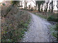
Footpath for Wellcross Grange leaving bridleway to the Downs Link path
Image: © Dave Spicer
Taken: 2 Jan 2010
0.07 miles
2
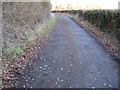
Bridleway that links Itchingfield to Horsham
Image: © Dave Spicer
Taken: 2 Jan 2010
0.07 miles
4
Silage bales and hay barn north of the Downs Link path
This barn area and surrounding field has a security barrier around and is WS CC property
Image: © Dave Spicer
Taken: 2 Jan 2010
0.17 miles
5
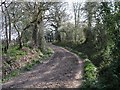
Mill Lane
Just south of Image Now closed to vehicular traffic the route is still frequently used by walkers, cyclists and equestrians.
Image: © Andy Potter
Taken: 7 Apr 2007
0.18 miles
8
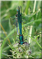
Mating Banded Demoiselles near Broadbridge Farm
Photograph taken on riverbank off footpath 1628/1.
Image: © Andy Potter
Taken: 1 Jul 2006
0.19 miles
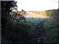
9
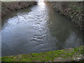
River Arun flowing under Mill Bridge
The river continues to flow in a northerly direction for another 3-4 KM before heading west and eventually southbound towards the sea at Arundel
Image: © Dave Spicer
Taken: 2 Jan 2010
0.20 miles
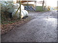
10
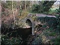
Mill Bridge, Mill Lane
Mill Lane once ran from the centre of Broadbridge Heath, past Corsletts Farm, over this bridge near Broadbridge farm and on to Itchingfield. Presumably this route fell into disuse with the construction of New Bridge 1km downstream to the west although it was thought worth protecting during WW2 with a roadblock and pillbox. It now carries bridleway 1630 and is blocked to vehicles.
Image: © Andy Potter
Taken: 7 Apr 2007
0.21 miles