IMAGES TAKEN NEAR TO
High Street, REDHILL, RH1 1RJ
Introduction
This page details the photographs taken nearby to High Street, RH1 1RJ by members of the Geograph project.
The Geograph project started in 2005 with the aim of publishing, organising and preserving representative images for every square kilometre of Great Britain, Ireland and the Isle of Man.

There are currently over 7.5m images from over14,400 individuals and you can help contribute to the project by visiting https://www.geograph.org.uk
Image Map
Images are licensed for reuse under creativecommons.org/licenses/by-sa/2.0
Notes
- Clicking on the map will re-center to the selected point.
- The higher the marker number, the further away the image location is from the centre of the postcode.
Image Listing (601 Images Found)
Images are licensed for reuse under creativecommons.org/licenses/by-sa/2.0
Image
Details
Distance
1
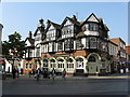
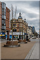
Redhill: The 'Junction'
Originally this pub stood at the main crossroads in Redhill. The pub. has not moved, but the streets have been pedestrianised, so it is now in the heart of the shopping area. A useful place for passing a pleasant hour while the wife does the shopping.
Image: © Dr Neil Clifton
Taken: 18 Apr 2011
0.00 miles
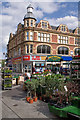
2
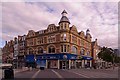
Junction of High Street and Station Road
Station Road on the left, High Street on the right. This was once the main Redhill crossroads, although now pedestrianised.
The building in the centre of the photo was built in the early 1900s to a near identical external design of a previous building which had only opened in 1900, but which had been destroyed in a major fire which took place on 25 May 1901, the worst in Redhill's history. It was occupied by R Nicol and Sons, Drapers and Furnishers, until 1933.
Compare Image and note the change of use from a year earlier.
The next building to its left, now occupied by a cycle shop, was an early branch of Sainsbury's - see http://www.francisfrith.com/redhill,surrey/photos/station-road-east-1906_55033/ for a photo in 1906.
Image: © Ian Capper
Taken: 29 Aug 2011
0.01 miles
4
Central Redhill
The buildings shown in Image from a different angle, along Station Road. The Harlequin Theatre on the right dates from 1986, while Lloyds Bank dates from about 1900.
Image: © Derek Harper
Taken: 15 Oct 2011
0.01 miles
5
Junction of High Street and Station Road
Looking along Station Road, with High Street on the right. This was once the main Redhill crossroads, although now pedestrianised. The market operates each Thursday and Saturday.
The building opposite was built in the early 1900s to a near identical external design of a previous building which had only opened in 1900, but which had been destroyed in a major fire which took place on 25 May 1901, the worst in Redhill's history. It was occupied by R Nicol and Sons, Drapers and Furnishers, until 1933.
Image: © Ian Capper
Taken: 17 Jul 2010
0.01 miles
6
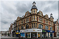
Junction of High Street and Station Road
Station Road on the left, High Street on the right. This was once the main Redhill crossroads, although now pedestrianised.
The building in the centre of the photo was built in the early 1900s to a near identical external design of a previous building which had only opened in 1900, but which had been destroyed in a major fire which took place on 25 May 1901, the worst in Redhill's history. It was occupied by R Nicol and Sons, Drapers and Furnishers, until 1933.
Compare Image for a 2011 photo - although the travel agents, Thomas Cook still occupy the ground floor of the building, the branding has changed.
Image: © Ian Capper
Taken: 1 Apr 2018
0.01 miles
7
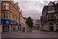
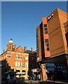
High Street
Looking along High Street from its junction with Station Road, originally the central crossroads in Redhill. On the right is the Junction pub (see Image) and in the background is the clock of The Belfry (see Image).
Image: © Ian Capper
Taken: 29 Aug 2011
0.01 miles
8
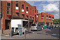
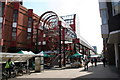
Station Road
The eastern section of Station Road, with restricted vehicular access. On the left is part of the Harlequin centre, built in the 1980s to replace the former Market Hall which has stood on this site from 1861 to 1982 (see http://www.francisfrith.com/redhill,surrey/photos/market-hall-1915_67817/ - this section of Station Road is off to the right).
Image: © Ian Capper
Taken: 17 Jul 2010
0.01 miles
9
High Street
Looking along High Street to its crossroad with Station Road.
Image: © Ian Capper
Taken: 1 Apr 2018
0.01 miles
10
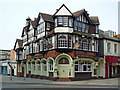
The Junction
Originally the Wheatsheaf, the present building dates from 1900 and is locally listed. In the late 1990s it was renamed the Firlot and Firkin, then in 2001 it became O'Neills, before receiving its present name in 2007.
Image: © Ian Capper
Taken: 4 May 2009
0.02 miles