IMAGES TAKEN NEAR TO
Cromwell Walk, REDHILL, RH1 1JA
Introduction
This page details the photographs taken nearby to Cromwell Walk, RH1 1JA by members of the Geograph project.
The Geograph project started in 2005 with the aim of publishing, organising and preserving representative images for every square kilometre of Great Britain, Ireland and the Isle of Man.

There are currently over 7.5m images from over14,400 individuals and you can help contribute to the project by visiting https://www.geograph.org.uk
Image Map
Images are licensed for reuse under creativecommons.org/licenses/by-sa/2.0
Notes
- Clicking on the map will re-center to the selected point.
- The higher the marker number, the further away the image location is from the centre of the postcode.
Image Listing (216 Images Found)
Images are licensed for reuse under creativecommons.org/licenses/by-sa/2.0
Image
Details
Distance
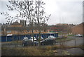
1
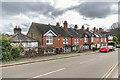
Cromwell Road Estate
A former council estate south of central Redhill. The railway is that running from Redhill to Guildford and Reading. It was opened in 1849 and is electrified as far as Reigate.
Image: © Ian Capper
Taken: 26 Apr 2008
0.02 miles
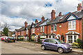
3
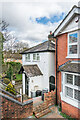
10 Linkfield Street
Victorian cottage in Linkfield Street.
Image: © Ian Capper
Taken: 1 Mar 2020
0.05 miles
4
10, 12 - 18 and 20 - 20c Linkfield Street
Victorian (no 10) and early 20th Century housing (the others) in Linkfield Street. The four plaques read from left to right: "1905", "Brandon Cottage", "Hilborough Cottages" and "1905".
Image: © Ian Capper
Taken: 1 Mar 2020
0.06 miles
5
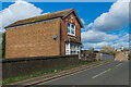
37 Linkfield Street
Single house on Linkfield Street next to the bridge over the Redhill to Reigate railway. A date plaque on the front is inscribed 1910.
Image: © Ian Capper
Taken: 1 Mar 2020
0.06 miles
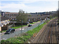
6
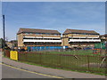
Housing in Fairfax Avenue
Viewed from Holland Close. On the left is Edgehill House, on the right is Marston House. In the foreground is the Fairfax Avenue Play Area.
Image: © Ian Capper
Taken: 26 Apr 2008
0.06 miles
7
12 - 18 and 20 - 20c Linkfield Street
Early 20th Century housing in Linkfield Street. The four plaques read from left to right: "1905", "Brandon Cottage", "Hilborough Cottages" and "1905".
Image: © Ian Capper
Taken: 1 Mar 2020
0.06 miles
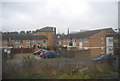
8
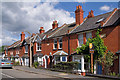
Linkfield Street
Edwardian cottages in Linkfield Street - the plaque on the right gives a building date of 1905. The road is much older, being one of the original lanes in the area.
Image: © Ian Capper
Taken: 12 Sep 2010
0.06 miles
9
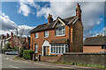
39 Linkfield Street
Early 20th Century house on Linkfield Street.
Image: © Ian Capper
Taken: 1 Mar 2020
0.06 miles